Kicking Off Storm Season
- Briefing Note 456
The warmer months in Australia see most of us looking forward to sunshine and holidays — especially now that lockdown restrictions are easing. For emergency services, Spring is also the beginning of storm and natural catastrophe season. Convective storms are consistently Australia’s costliest catastrophes, causing damage from large hail, wind gusts and flash flooding to homes, business, crops and vehicles.
October has seen an onslaught of severe storm events already. A low pressure trough over central Australia moved east last week, triggering multiple storm warnings from the Bureau of Meteorology for the coast The trough ultimately eventuated in several noteworthy events (summarised in Table 1).
| Date | Locations | Damage metrics | Reported impacts |
Oct. 15, 2021 | Armidale | Tornado | Reportedly 1000 homes damaged; no major injuries |
Oct. 15, 2021 | Gympie | 6cm hail | None reported |
Oct. 18, 2021 | Toowoomba, Bracewell | Tornado | No reports of damage or injury |
Oct. 19, 2021 | Mackay (Yarlboroo) | 16cm hail | Damaged windscreens; 1 call for assistance |
Oct. 20, 2021 | Mackay, Mt. Morgan, Rockhampton | 6cm hail, 3cm hail, 120km/h wind-gusts | Upturned and hail-dented aircraft at Mackay Airport; downed power lines. |
Oct. 20, 2021 | Toormina | Golf-ball sized hail, 40cm hail depth on Toormina Road. | 976 calls for assistance from SES; roof/skylights damage and collapses; water damage from dammed gutters |
Oct. 22, 2021 | Brisbane | Tornado | Structures damaged at Brisbane Airport |
Oct. 28, 2021 | Adelaide | Golf ball sized hail | 1200 calls for assistance from SES; power outages; crop damage; shattered windscreens |
The hours clause will cause many of these storms to constitute one event. Of note from Table 1 are the record-breaking hailstones in Yaramaroo and the hailstorm that hit Coffs Harbor on Wednesday (the 21st). Queensland’s monstrous hail was confirmed at 16cm, or “grapefruit-sized.”[1] This is 2cm greater than the previous record — also set in Queensland, on Halloween last year! The Mackay region only saw a brief reprieve before receiving more hail the next day.


Hail size estimates derived from radar (Figure 1) show a widespread storm system aligned with the coast near Mackay, narrowly missing the town itself. Typically, in these analyses, the location of extreme hail sizes aloft does not align spatially with where these hailsizes are observed on the ground. The accepted explanation for this is wind drift as the hail falls. In this case, because the hail sizes are so extreme, that may in part explain why the hail would not have drifted far from its storm cell of origin. Other neighboring storm cells, especially south of Mackay, display the potential to have formed record-breaking hailstones as well, but population density plays a role in these records. The observational bias towards more populated areas is an ongoing challenge when analysing trends from historical records.
The Coffs Harbour storm heavily impacted the town of Toormina, with images of hail covering the ground in drifts as if by snow even a day later. State Emergency Services received 976 calls for assistance for items like collapsed roofs, fallen trees and blocked roads. Reported and photographed hail sizes were as large as golf balls, but were primarily smaller, in large quantities, accumulating and damming gutters and streets. On Toormina Road, the accumulated hail reached depths of 40cm.
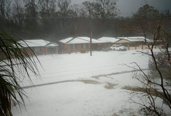
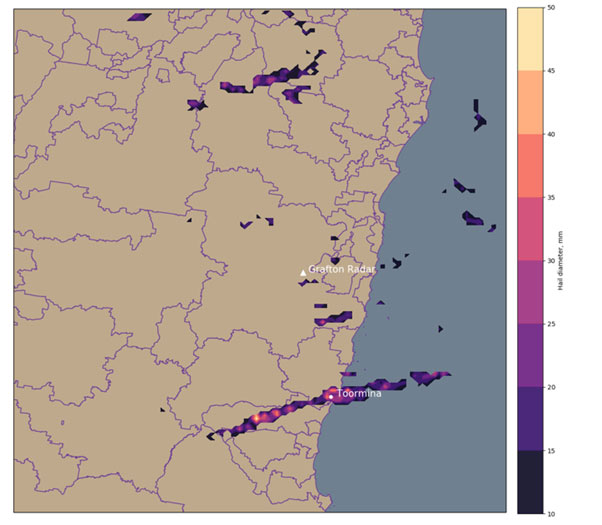
Unlike the storm in Northern Queensland, the system that impacted Coffs Harbor is highly localised and less severe — note the color scaling is different between Figures 2 and 4. However, the Coffs Harbour region is more populous than Mackay. In addition to Toormina, severe hail was experienced in Boambee, just to its North, and nearby Sawtell Beach. Whether or not advection (the drift due to wind) is evident here may become more apparent as damage reports become available. Upon inspection of the area, to the south and west are mainly forests or state-park, which would not incur significant insurance losses.
Finally, Adelaide was impacted by severe hail on October 28th, comprised of multiple storm tracks, damaging crops in the Barossa Valley and Northern Adelaide and leaving many without power. Hailstones as large as 5cm were reported, along with wind gusts in excess of 100km/h. One zucchini farm in Penfield experienced estimated crop losses of $60,000, and many vineyards are anticipating great losses based on fruit damage so far.
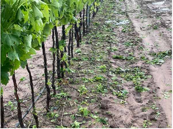
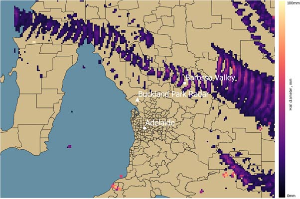
Hailstorms mainly occur between October and February, but peak season is considered November-December. IAG has already declared that these October storms have hit retention, stating that, “the net cost for this event is anticipated to be $169 million, the maximum retention for a first loss under IAG’s catastrophe program.” The analyses in Figures 2, 4 and 6 are derived from applying the Maximum Estimated Size of Hail algorithm to radar over the course of the storm. Contact Risk Frontiers for loss estimates from these storm footprints or other information from the analysis.
In addition to the hailstorms in Table 1, multiple tornadoes impacted Queensland and New South Wales. A tornado caused damage in Armidale on October 17th and to Brisbane airport on October 22nd. A discussion of tornadoes, their occurrence, forecasting and modelling in future climates will be the focus of a future briefing note from Risk Frontiers.
About the author/s

Salomé Hussein
Salomé is our expert in machine vision, radar analysis, and robotic process automation (RPA). She holds a PhD in Physics and specialises in modelling hail and agriculture.
