Menu Close

Hurricane Helene: The significance and destruction

 Jacob Evans, Risk Frontiers
 

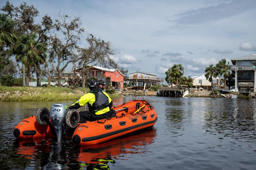
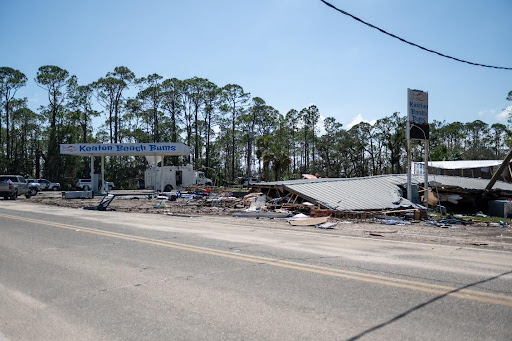
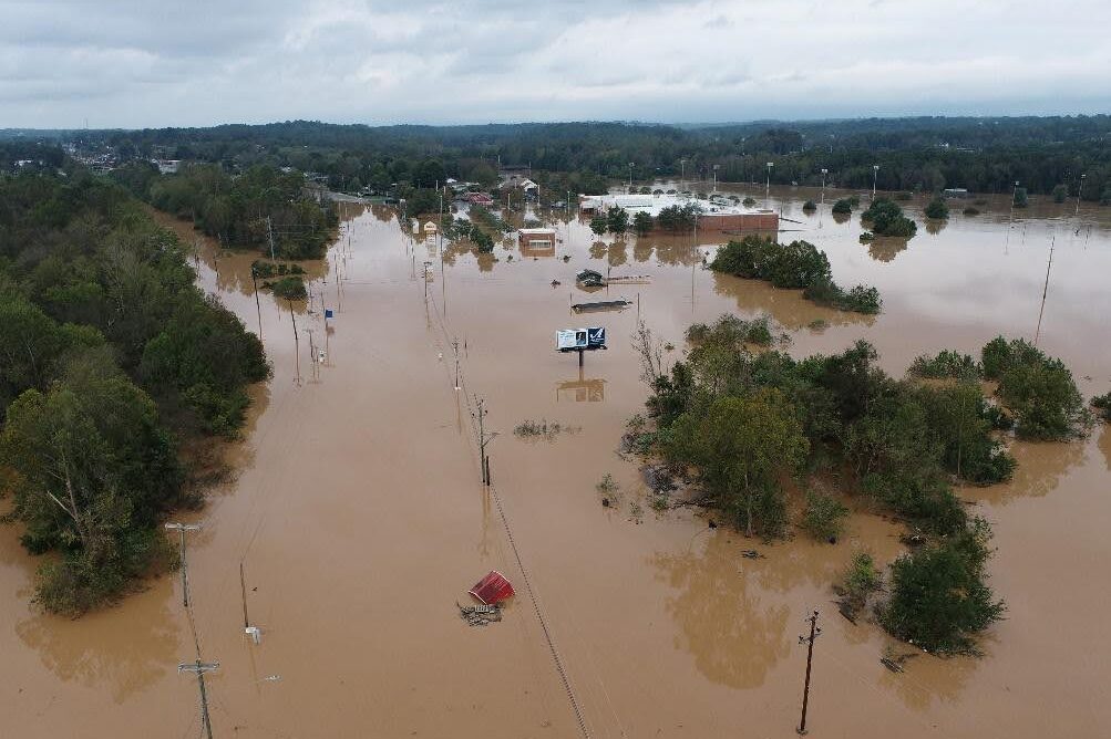
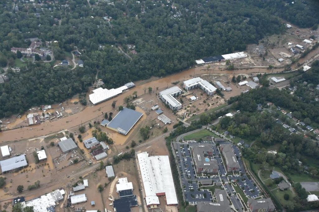
Hurricane Helene was the strongest hurricane (tropical cyclone) on record to strike the Big Bend region of Florida. It caused significant damage and destruction along its path with widespread flooding across America’s Southeast.

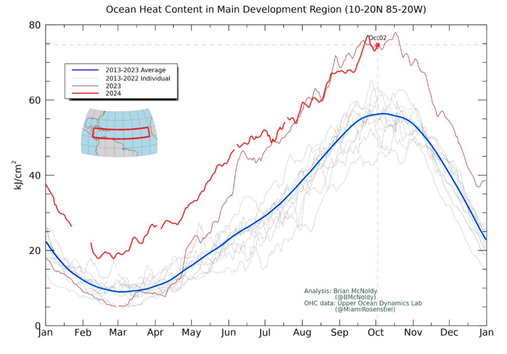
Helene had an unusual formation, developing from a Central American gyre (CAG). Helene had maximum sustained winds of 220 km/h, and gusts of 245 km/h. It brought a 4.6 m storm surge in areas along Florida’s coastline, and extreme rainfall in the southeastern United States with 80 cm of rainfall in Busick, North Carolina. The National Water Center (NWC) calculated more than 40 trillion gallons of rain drenched America’s Southeast in the last week surrounding Hurricane Helene.

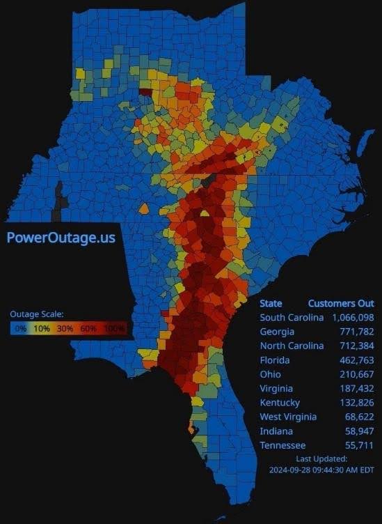
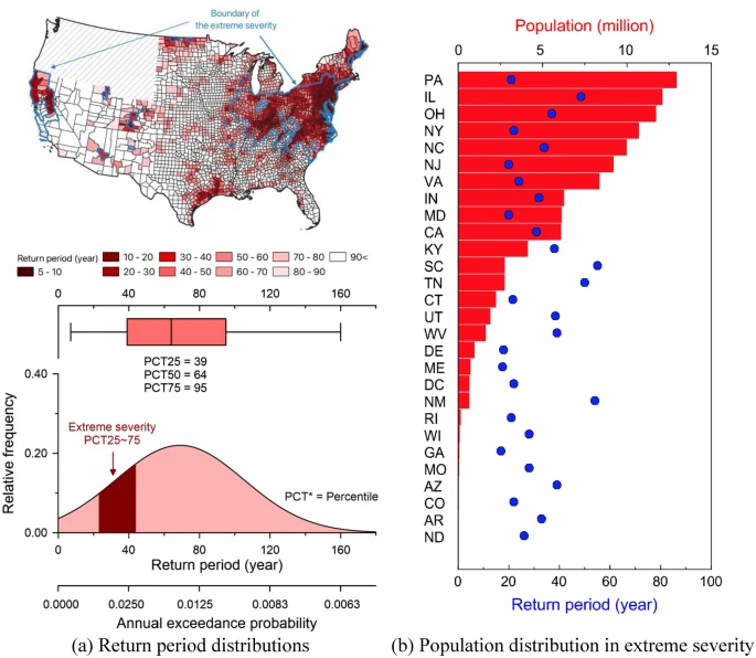
As of the 1st of October, 130 people have lost their lives with more than 600 people still missing. Initial estimates by Moody’s for the insured losses are between $20-34 billion USD, whilst AccuWeather Inc. estimated that the total damage and economic loss could cost between $145-160 billion USD.

Central American gyres

CAGs are a type of monsoonal low that are broad, closed, slow-moving cyclonic circulations that typically develop during the rainy season (May-June and October-November) in an area of low pressure over the eastern Pacific Ocean and western Caribbean Sea. As CAGs are slow-moving systems with warm ocean waters nearby, they can produce abundant amounts of rainfall. CAGs can both promote hurricane formation, usually over the western Caribbean Sea and southern Gulf of Mexico as is the case for hurricane Helene, and/or influence hurricanes track and intensification.
CAGs consist of a central broader gyre within which smaller vortices rotate. These small vortices are associated with increased thunderstorm activity, and can develop into more mature tropical storms with the interaction of passing tropical waves increasing their vorticity. Some tropical storms may then develop into hurricanes and detach from the gyre if the environment is favorable for such development.

Formation

In the case of Helene, meteorologists suggested that a surge of the Madden-Julian Oscillation (MJO), which is a tropical wave propagating eastward from the Indian Ocean into the eastern Pacific, promoted stronger convection within an existing CAG which was in turn associated with hurricane Helene’s formation.

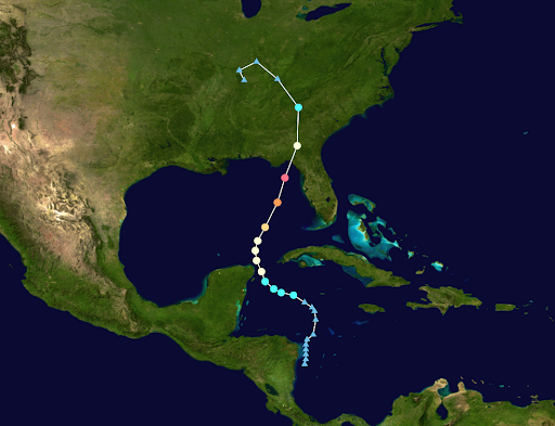
On the 24th of September a tropical storm had formed 4 days after the development of a CAG over central America, and developed into hurricane Helene on the 25th of September. Helene then rapidly intensified as it parted from the CAG and traversed the Gulf of Mexico, becoming a Category 4 hurricane on the 26th. Helene crossed the coastline later that evening along the Big Bend region of Florida. The rapid intensification is attributed to warm ocean temperatures (1-2 degrees above normal), high moisture, and low atmospheric wind shear.

Landfall

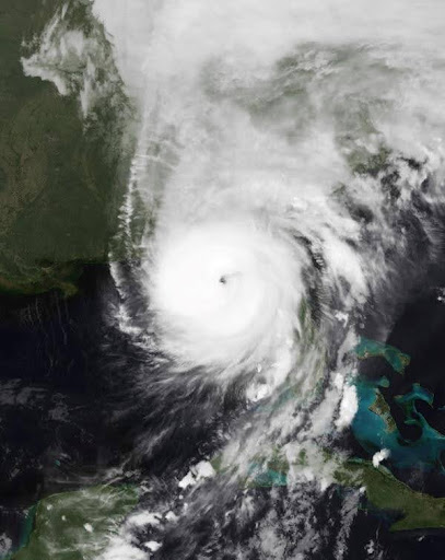
Hurricane Helene made landfall late on the 26th of September as a Category 4 hurricane. It crossed the coastline in the Big Bend region of Florida. It had maximum sustained winds of 220 km/h, with gusts of 245 km/h.

Helene moved with a considerable translational speed of 48 km/h, double the typical forward speeds of hurricanes that impact the area. It quickly downgraded to a Category 2 system whilst rapidly tracking over Georgia and continuing inland crossing the western corner of North Carolina and into Tennessee where it downgraded to a low-pressure system. It then ventured north into Kentucky, briefly entered Indiana before returning back and decaying along the Kentucky-Tennessee border.

Figure 1. The path of Hurricane Helene. Source: Wikipedia.
Figure 2. NOAA’S GEOS-16 Satellite imagery of Hurricane Helene approaching Florida, United States. Source, NOAA.

Damage

Four days after Hurricane Helene made landfall there were still no detailed reports on the extent of the damage, an indicator as to how widespread and destructive Helene was. Experts are calling Helene a ‘perfect storm’, as it started big, went over warm water resulting in rapid intensification while intaking tremendous amounts of water, made landfall at an area that is prone to high storm surge, and then accelerated into populated areas deep within the United States.

Helene brought destruction in the form of wind, storm surge and flooding. These three perils have resulted in over 4 million people without power, with 2 million still waiting for their power to be connected four days later. Communication lines (mobile phone and internet services) have been damaged leaving large areas without coverage, significantly hindering search and rescue efforts. Roads have been blocked by debris, with several underwater as well, leaving communities isolated. Several communities are also without necessities. The Florida National Guard alone has so far distributed 821,772 water boxes, 630,222 Meals Ready-to-Eat, 15,798 ice bags, and 27,800 tarps.

The impacts of the three perils are listed below.

Wind

So far there are no post-disaster reports detailing the impact of wind. However, with maximum sustained winds of 220 km/h it is likely that a large number of homes have been impacted. Though with the utter devastation caused by storm surge in Florida it may be difficult to distinguish between buildings damaged by wind or storm surge. Authorities in Florida are stating some homes have turned to rubble. Florida’s government has also announced it will be bringing travel trailers for people to live in while repairs are made on their homes. In Suwannee County authorities reported extreme destruction with trees falling onto homes.

Storm Surge

Helene brought unprecedented levels of storm surge as it coincided with high tide conditions, with homes in coastal areas of Florida being the worst affected. It reached up to 4.6 m along portions of the coastline in Taylor and Dixie counties in Florida, records for the areas. Holmes Beach, an island community of Florida, is said to be completely devastated. A house fire even broke out amidst the coastal flooding, believed to be related to a golf cart battery. Similarly, Cedar Key island is reported to be totally devastated. Entire houses are missing or flattened in on themselves, and local businesses destroyed including the local food market. Meanwhile, for Keaton Beach on mainland Florida there is total devastation, and for Steinhatchee the houses looked as though they were floating in high waters at one point.

Before Helene made landfall the Taylor County Sheriff’s office released the following grim message: “If you or someone you know chose not to evacuate, PLEASE write your, Name, birthday and important information on your arm or leg in A PERMANENT MARKER so that you can be identified and family notified”, such was the threat from high windspeeds and storm surge.

Figure 3. The aftermath from Helene’s storm surge in Keaton Beach, Florida, United States. Source: USCG South East.
Figure 4. Buildings flattened from Helene’s storm surge in Keaton Beach, Florida, United States. Source: USCG South East.

Flooding

The flooding from Helene has been the most destructive and caused most of the fatalities. The velocity and sheer volume of water have swept away communities and left residents isolated with roads under water, bridges washed away, power lines looking like spaghetti, and communication towers damaged. North Carolina has been the most impacted by flooding from Helene. The nearby states of South Carolina, Georgia, Florida, Tennessee and Virginia have also been significantly impacted. Landslides are also occurring along steep terrain across the Southern Appalachians due to the sheer volume of rain.

According to the Governor of North Carolina, communities have been ‘wiped off the map’. The mountainous community of Asheville, North Carolina, in Buncombe County is one of the hardest-hit areas recording 35 cm of rainfall. Asheville is completely isolated, with residents struggling to find food, water, and cell phone service for the last four days. The National Climatic Data Center is also based in Asheville, and without water and electricity services the facility is inoperable. This has severely limited the assessment of the magnitude and severity of Helene. To make matters worse, North Carolina also endured two confirmed tornadoes, which reportedly damaged 11 buildings and injured 15 people during the impacts of Helene.

Nearby communities in the mountainous region of western North Carolina have also seen homes and bridges washed away or flattened. Weaverville has had much of its infrastructure destroyed, and as its water plant was flooded residents have been without drinking water for four days. The communities of Morganton and Waynesville have also experienced similar impacts, and the small town of Boone has experienced a mudslide. There is also a warning in Rutherford County, North Carolina, as the dam has been compromised and poses an imminent threat to residents. After several days 22 acute care hospitals in North Carolina are back on the power grid after being on generator power.

Several communities in Tennessee have also experienced severe flooding. The Unicoi County Hospital had all hospital staff and patients evacuated from the hospital roof due to rising floodwaters.

In Georgia, Atlanta and several other communities have also endured flash flooding. Damage is reported to have occurred in all 159 counties, with the state experiencing widespread power outages. The top emergency management official in Jefferson County has stated that the sheer number of communities affected by storm damage in Georgia has made it very difficult to provide help to the people who need it.

Figure 5. The flash flooding in North Carolina, United States. Source: NC DOT.
Figure 6. The impact of the flash flooding at Asheville, North Carolina, United States. Source: NC DOT.
Figure 7. Power outages on the 28th of September along the east coast of the United States. Source: University of Georgia.

Impact of a changing climate

Hurricane Helene was the 14th most powerful storm to hit the United States since records began in 1851. Helene was approximately 675 km wide, making it the 3rd widest hurricane, only behind Ida (2017) and Opal (1996), both of which were 740 km wide. The fact that two of the top 3 widest hurricanes have occurred in the last eight year is remarkable.

Storms such as Helene can hold more moisture as temperatures increase. The air holds 7% more moisture for every degree Celsius warmer. Global average temperature for the 12-months to August 2024 was 1.64C above the pre-industrial (1850-1900) average, meaning storms are bringing more rainfall than they have previously. Scientists at the Department of Energy’s Lawrence Berkeley National Lab determined that climate change caused 50% more rainfall during Helene for some parts of Georgia, North Carolina and South Carolina, using a method published in a study about Hurricane Harvey’s rainfall (Source: Twitter/BerkeleyLab).

Hurricanes are also undergoing rapid intensification more often too, due to warming ocean temperature, as discussed earlier in this briefing. The record water temperatures experienced during Helene’s formation (Fig. 8) have been made significantly more likely by climate change. As the climate system warms, ~90% of the excess heat is being stored in the ocean, and the North Atlantic Ocean as a whole has seen record warm temperatures in 2024.

Just last year Florida was impacted by Hurricane Idalia (August 2023); similar to Helene, Idalia underwent rapid intensification and brought heavy rainfall in the same area of the United States. While direct attribution of these events to global warming is difficult, the rapid intensification, large amounts of available moisture in the surrounding environment, and manifestation as locally heavy rainfall totals are all consistent with expected hurricane behaviour in a warming climate.

For rainfall, large rain events are becoming more intense and frequent. This is making the 1-in-100-year event obsolete, according to a 2023 report from the First Street Foundation (Fig. 9) (First Street Foundation 2023). For America, more than 50% of the population is twice as likely to encounter a 1-in-100-year precipitation event than previously thought. Encountering a 1-in-100-year precipitation occurs even more frequently in coastal areas, where the majority of major population centers are located. Compared to NOAA’s Atlas 14 precipitation data, the report found that parts of Western North Carolina could encounter a 1-in-100 year flood every 11 to 25 years. Even more alarming, in the Northeast, the Ohio River Basin, Northwestern California, the Texas Gulf Coast and the Mountain West, the 1-in-100-year rainfall event could occur every 5 to 10 years. It should be noted that NOAA are in the process of developing Atlas 15, an update to Atlas 14 precipitation data which will be released in 2027.

To put Helene in perspective, the daily rainfall total of 30 cm in Celo equates to the 1-in-500 year total per NOAA Atlas 14 precipitation data. In Asheville, the three-day rainfall total of 36 cm is well beyond the 1-in-1000 year total of 29 cm, and for Mount Mitchell the 62 cm over three days is significantly above the 1-in-1000 year rainfall amount of 42 cm.

Figure 8. The ocean heat content averaged over the Gulf of Mexico was at record highs during the formation of Hurricane Helene. Source: UM.
Figure 9. The increase in extreme precipitation events due to climate change in mainland United States. Panel (a) presents spatial (upper) and quantitative (lower) distributions of median return periods derived from the 21st-century records to precipitation depths corresponding to a 1-in-100-year return period of NOAA Atlas. The distribution is from the counties categorized as the extreme. Panel (b) depicts a distribution of populations exposed to the extreme severity of increased extreme precipitation. Source: First Street Foundation 2023.

Implications for Australia

In 2023, Far North Queensland, Australia, was devastated by Severe Tropical Cyclone Jasper. Jasper was the wettest tropical cyclone in Australian history, with total rainfall peaking at 225 cm at Bairds near the Daintree River. This follows a worldwide trend of cyclones causing more rainfall. 

The Climate Council of Australia (Climate Council 2024) notes that climate change is increasing the destructive power of tropical cyclones, as these events are occurring in an atmosphere that is warmer, wetter, and more energetic than in the past. It also notes that it is likely that maximum windspeeds and the amount of rainfall associated with tropical cyclones is increasing, and other aspects in cyclone formation and behavior may be changing as well, such as speed at which they intensify, the translation speed, and how much strength is retained after reaching landfall. Storm surge may also be intensifying with rising sea levels. All these factors are making cyclones more dangerous.

The 2023 IPCC report on climate change (IPCC, 2023) note it is likely that the number of cyclones is decreasing overall. However, it is likely that the global proportion of major (Category 3–5) tropical cyclone occurrence has increased over the last four decades, with those that do form becoming more intense and costly. In fact, the Climate Measurement Standards Initiative (CMSI) reports that there is a low-medium chance that Australia is likely to encounter an increased number of severe destructive and costly tropical cyclones.

References

Climate Council 2024. TROPICAL CYCLONESAND CLIMATE CHANGE: FACTSHEET.

CMSI. Climate Measurement Standards Initiative Scenario analysis of climate-related physical risk for buildings and infrastructure: Climate science guidance TECHNICAL SUMMARY

First Street Foundation 2023. Kim, J., Porter, J. & Kearns, E.J. Exposure of the US population to extreme precipitation risk has increased due to climate change. Sci Rep 13, 21782 (2023). https://doi.org/10.1038/s41598-023-48969-7

IPCC, 2023: Climate Change 2024: Synthesis Report. Contribution of Working Groups I, II and III to the Sixth Assessment Report of the Intergovernmental Panel on Climate Change [Core Writing Team, H. Lee and J. Romero (eds.)]. IPCC, Geneva, Switzerland, pp. 35-115, doi: 10.59327/IPCC/AR6-9789291691647.

About the author/s
Jacob Evans
Risk Scientist at Risk Frontiers | Other Posts

Jacob has been involved in the development of our FloodAUS, CyclAUS and QuakeAUS Cat-Loss models. He specialises in data science and mathematics.

Jacob received his PhD in Condensed Matter Physics from Macquarie University. Jacob’s interests include data science, numerical modelling, physics and mathematics.

Joining Risk Frontiers in 2017, Jacob has worked across a range of projects from model development and climate risk management to resilience and portfolio modelling.

Notably, Jacob has employed techniques such as machine learning and statistical analysis to understand the vulnerability of risk across Risk Frontiers catastrophe suite, as well as applying machine learning algorithms for flood, cyclone and earthquake models. He also works on hazard and loss modelling.

Interested in Learning More About our Australian Tropical Cyclone Loss Model CyclAUS?

CyclAUS is Risk Frontiers’ detailed Australian Tropical Cyclone loss model bringing cyclone risk down to a location and portfolio level loss. Risk Frontiers’ experts have combined decades of development to model a 50,000 years stochastic event set representing more than 300,000 individual events based on all historical Tropical Cyclones observed in the last 50 years. Vulnerability models translating maximum wind speeds to loss values have been carefully developed using a combination of insurance claims data and on the ground post-event surveys.

Risk Frontiers is continually working on updating CyclAUS based on the latest cutting-edge peer-reviewed methodology to provide Australian communities the most accurate Tropical Cyclone risk and help build towards a more resilient future.

Our team is ready to answer your questions.