During the last week of August and into early September, Southern Australia experienced a prolonged period of very strong winds due to a series of cold fronts and a deep low-pressure system over the Southern Ocean. The Bureau of Meteorology (BOM) issued ten consecutive days of severe weather warnings for extreme winds. Wind gusts exceeding 150km/hr were recorded at several mainland weather stations, including Thredbo and Wilsons Promontory. Tasmania felt the brunt of the storm, with many stations recording their highest ever wind speeds, including 187km/hr at Maatsuyker Island—equivalent to a Category 2-3 tropical cyclone (BOM).
These winds, and associated heavy rainfall, caused widespread damage throughout Victoria and Tasmania. Across Victoria, over 660 buildings were damaged and 180,000 homes lost power (Insurance News). There were also two fatalities due to falling trees (one in Victoria, one on the NSW-Victorian border). In Tasmania, hundreds of homes were damaged and about 37,000 lost power and there were flood warnings on multiple rivers, with evacuations along the Derwent River (which reached record flood levels) (The Guardian)).
Severe storms capped off a record breaking month around the country, with the national area-averaged mean temperature 3.03°C warmer than the 1961–1990 average: the warmest August on record since 1910 (BOM). Multiple locations across Western Australia recorded temperatures above 40°C, the first time on record this has occurred in winter. Many stations also set records for the number of consecutive days with maximum temperature at 30°C or above in August. Hot windy conditions, described by Mountainwatch as the ‘Hairdryer northwesterlies’, have decimated alpine snowpacks, forcing the early closure of ski resorts in Australia and New Zealand.
It is highly likely that the origins of this anomalous hot-windy weather can be traced back to a series of sudden stratospheric warming events (SSW) over Antarctica in July and early August. Stratospheric temperatures over Antarctica are usually around -80 C, but on July 7th they jumped by 15°C; then, after briefly cooling off in mid-July, they jumped again on August 5 by 17°C (NASA).
This event was widely reported in the media (e.g. . ABC), because SSW are relatively rare in the southern hemisphere, and the July warming was the first mid-winter event seen in 44-years of observations (NASA). It was speculated that the event would probably cause unusual weather in the coming weeks, including strong winds over southern Australia and New Zealand (e.g. NIWA). The last SSW was in spring 2019, which saw a succession of fronts driving strong hot dry winds over southeast Australia and contributing to severe bushfire weather during the 2019-2020 Black Summer.
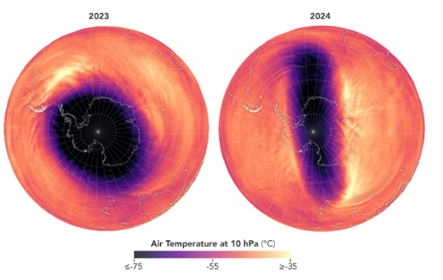
The SSW had an immediate effect of perturbing the circumpolar vortex; Figure 1 shows the regular symmetrical pattern of stratospheric air temperatures in 2023 compared to the unusual, elongated pattern associated with the SSW in 2024 (NASA). There was a weakening of the circumpolar westerlies and a shift to the strongly negative phase of the Southern Annual Mode (SAM)—characterised by increased air pressure over the Antarctic continent and lower pressure over the Southern Ocean. Under these conditions, the westerly storm track can become more meridional and push further north in some regions.
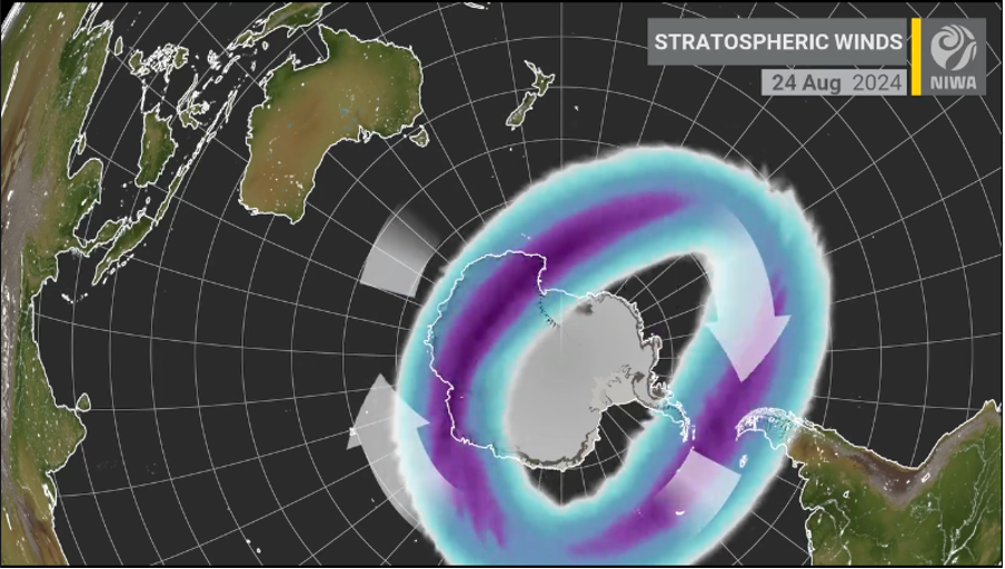
There was some expectation that the SSW might drive increased winter storm activity over southern Australia, which appeared to be supported by a cold outbreak in late July (NASA). However, by August the storm track had shifted far to the south of Australia and a high-pressure system established over the continent, which dominated the weather for the rest of the month. Meanwhile, in South America, the storm-track shifted northwards, bringing cold conditions and heavy snowfalls to Chile and Argentina. Figure 2 shows the polar vortex and stratospheric winds displaced towards South America and away from Australia during mid-to-late August.
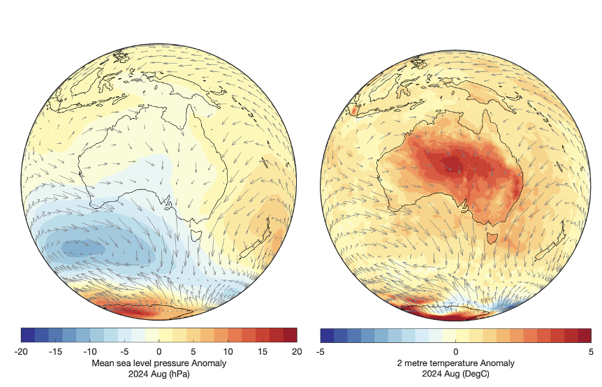
Persistent high pressure over Australia, especially the eastern states, brought stable conditions and allowed an extraordinary build-up of heat over the continent (Figure 4). It also strengthened the pressure gradient between the Australian mainland and the Southern Ocean—setting the scene for a late August windstorm.
Wind is simply air moving to equalise differences in pressure; the larger the pressure gradient, the stronger the winds. Differential heating of Earth’s surface is the main cause of pressure gradients that drive winds. So as the Australian mainland heated through August, this caused higher pressure aloft, increasing the pressure gradient between air masses above the Australian mainland and the Southern Ocean. About 12km above the largest horizontal temperature gradient there is a relatively narrow band of fast-moving air called the jet stream; the stronger the temperature gradient, the stronger the jet stream.
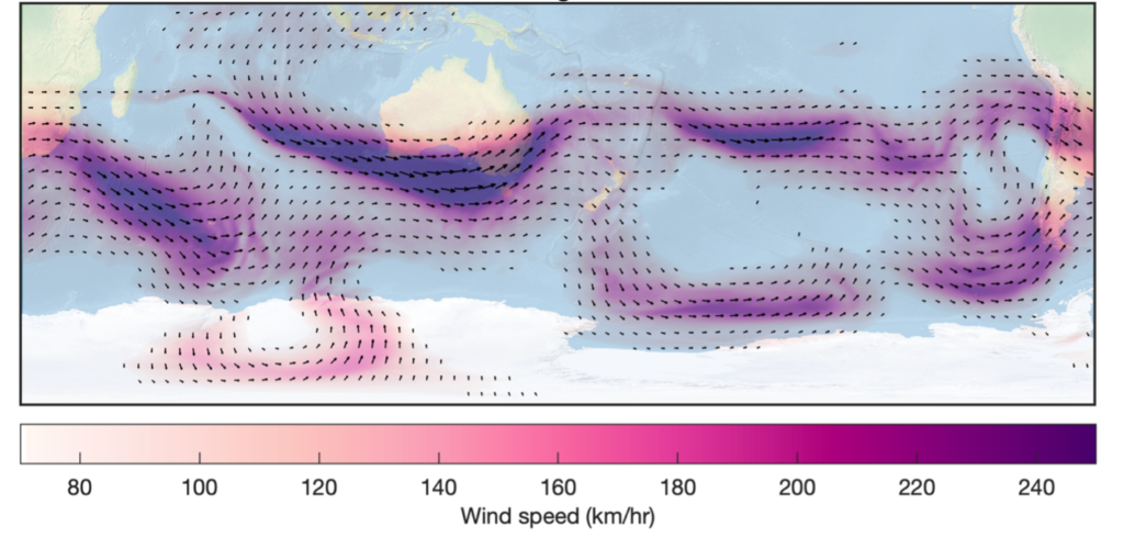
Jet streams have a huge effect on surface weather; a strengthening and merging of the subtropical and polar jets has been implicated as the primary cause of damaging winds over southeast Australia in late August and early September (e.g. SMH). Figure 4 shows an illustration of the strengthened jet over southern Australia during the strong wind events which impacted Tasmania and Victoria.
Definitive attribution of recent windstorms to the SSW is difficult as there is still uncertainty around the way SSW affect tropospheric weather. However, the experience this year is in-line with predictions made at the time of the SSW event in July (e.g. UNSW), and the experience of the 2019 SSW which preceded anomalously hot dry winds and severe bushfire weather during Australia’s Black Summer.
The role of anthropogenic warming is also unclear but cannot be dismissed. SSW are considered rare, with the only previously observed events occurring in 2002 and 2019 (and possibly 2010, depending on the precise definition used). They are expected to occur only once every 22 years, and even less frequently in a warmer climate (Jucker et al 2021); yet it has been less than five years since the last event. SSWs seem to be initiated through disturbances in surface weather (Jucker et al 2023) and, after 14-consecutive months of record-high global temperatures (WMO 2024), there has been no shortage of anomalous surface weather events.
For southeast Australia this SSW event has most likely contributed to an early onset of spring-like conditions, driving extraordinarily persistent and damaging winds, desiccating the landscape and increasing bushfire risk. Whether it’s influence will continue through until summer remains to be seen. But one thing for sure, it there won’t be much skiing on the Australian Alps this spring.