Mansfield earthquake 22 September 2021 magnitude 5.9 – what caused it, and preliminary impacts
The 22 September 2021 magnitude Mw 5.9 Mansfield earthquake occurred at 9:21 am local time with an epicentre at latitude 37.491°S, longitude 146.363°E, depth: 10.0 km, about 130 km northeast of Melbourne. This is the largest earthquake to have occurred in Victoria since European settlement.
Association of the Mansfield Earthquake with Identified Faults
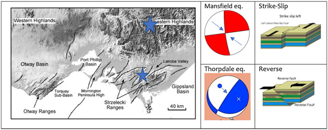
The earthquake did not occur near any identified potentially active faults (Figure 1), and it remains to be seen if the earthquake caused surface rupture of the ground. All earthquakes occur on faults, but earthquakes smaller than the Mansfield earthquake are generally not expected to cause surface rupture in southeastern Australia because they have small fault dimensions (about 1 km for Mw 4 and 3 km for Mw 5). The Mansfield earthquake, with Mw 5.9 and dimension of about 10 km, is at the threshold at which surface rupture could occur, although its focal depth of 10 km probably precluded that. In contrast, earthquakes that occur in the cratonic regions of central and western Australia have shallow depths, and so even quite small earthquakes break the ground surface there (King et al., 2019).

The focal mechanism of the Mansfield earthquake, shown in map view on the right of Figure 1, indicates that it occurred either as left-lateral strike-slip on a vertical north-northwest striking fault or right-lateral strike-slip on a vertical east-northeast striking fault. In either case, it accommodated crustal shortening in the northwest-southeast direction, as shown by the blue arrows.
The fault that lies to the southeast of the Mansfield earthquake epicentre on the left side of Figure 1 is the Yallourn Monocline. It seems possible that it extends up the valley to the north-northwest and may be associated with the fault on which the Mansfield earthquake occurred. The north-northwest orientation of one of the planes in its focal mechanism (right side of Figure 1) has a strike that is roughly parallel to that of the northern end of the Yallourn Monocline.
Association of the Mansfield Earthquake with the Stress Field in Southeastern Australia
In contrast to the Mansfield earthquake, which occurred as strike-slip motion on a vertical fault plane, the 19 June 2012 Mw 5.2 Thorpdale, Gippsland earthquake (Attanayake et al., 2019) occurred as reverse faulting on a dipping fault plane, as illustrated in Figure 2. However, both earthquakes had the same long-term geological result: they both accommodated crustal shortening in the northwest-southeast direction, as indicated by the blue arrows in both focal mechanisms.

Origin of the Stress Field in Southeastern Australia
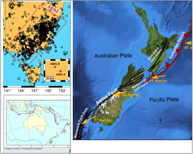
As shown in the lower left panel of Figure 3, Australia is surrounded by tectonic plate boundaries. The closest of these is the Indonesian subduction zone off the northwest coast of the Northern Territory and Western Australia. However, southeastern Australia may be more strongly impacted by the boundary between the Australian and Pacific plates, as shown in the right panel of Figure 3. This shows the convergence and collision of the Pacific plate with the Australian plate along the plate boundary faults that run through New Zealand, extending from the Hikurangi subduction zone off the east coast of the North Island to the Alpine fault that runs down the west coast of the South Island.
Although the Alpine fault is thought to be primarily a strike-slip fault, with the east side moving southwest with respect to the west side, there is also a component of convergence perpendicular to the Alpine fault, as indicated by the yellow arrows. The northeast-southwest orientation of the Alpine fault is roughly parallel to the orientation of the Southeastern Seismic Zone (SESZ; Attanayake et al., 2019) on the left panel of Figure 3, and the direction perpendicular to both of these is approximately northwest. This is presumably the cause of the northwest-southeast direction of maximum horizontal compression in the Thorpdale and Mansfield earthquakes, and noted in previous earthquakes (Denham et al., 1981; Denham and Ellis, 1986) and analyses of the stress field orientation (Rajabi et al., 2017).

Shakemap
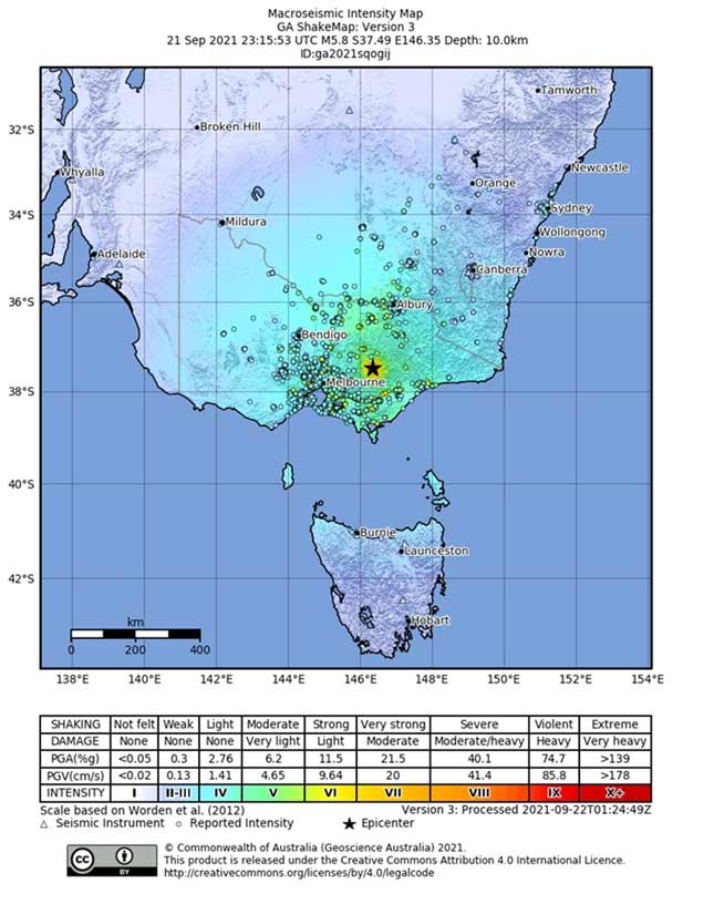
The intensity shakemap generated by Geoscience Australia (Figure 4) estimates that MMI Intensity VI (strong shaking with light damage potential) occurred in the epicentral region; MMI Intensity V (moderate shaking with very light damage potential) occurred on the northeastern outskirts of Melbourne, and MMI Intensity IV (light shaking with no damage potential) occurred in Melbourne. The occurrence of some nonstructural damage in Melbourne probably indicates that the affected structures were very weak. This map is consistent with the low level of damage that has been reported to date and is summarised next.

Impacts
The earthquake was felt as far afield as Sydney, Dubbo, Launceston and Adelaide, all at least 700 km away. Tall residential apartments of up to 50 stories swayed for as much as 20 seconds, triggering panic among residents. Power outages were reported across parts of metropolitan Melbourne.
The earthquake was followed by six aftershocks, the first a magnitude 5.5 event at 9.40am, followed by a magnitude 4.0 event at 9.55am and a magnitude 3.1 event at 10.15am. The earthquake sequence could last several weeks to several months or more, with event frequency decreasing with time. It seems likely that the aftershocks will occur near the mainshock and, if so, they probably have low potential to cause damage because of the remote location of the mainshock.
To date, no deaths or injuries have been reported. The impacts reported to date include:
- Partial wall collapse of Betty’s Burgers restaurant on Chapel St, Windsor, with some overhead cabling also down (probably power line).
- Bricks fallen from archway of Coles building on Wattle St, Prahran
- 46 reports of minor building damage across the state, including the Melbourne suburbs of Kensington, Ascot Vale, Parkdale, Prahran, Balwyn, Elsternwick, Northcote and West Melbourne
- Numerous reports of furniture moving or shaking and things falling from tables and shelves, including from a Chemist Warehouse in Mansfield
- Reports of 35,000 residents without power, including Beechworth Hospital (which switched to backup generators)
- A report from Licola (near the epicentre) of broken windows, cracked ceilings and “everything out of our cupboards fell out”
- Evacuations of residential and commercial buildings from inner Melbourne, including one area of the Queen Elizabeth Hospital in Woodville (“as a precaution”), some buildings in Adelaide including buildings belonging to Adelaide University and (claimed by a Facebook user) buildings as far north as Newcastle
- Impacts to public transport, including on the Traralgon and Seymour rail lines, and all rail services were stopped between Parkes, Cootamundra, Melbourne and Wolseley as a precaution
- Swaying felt across Melbourne, regional VIC, Sydney, Newcastle, regional NSW, and the ACT, particularly in high rise buildings
- VICSES reported 100 requests for assistance “largely in relation to minor structural damage such as facade and chimney collapses”
- Damage reported to an Ambulance Victoria dispatch bay in Mansfield
- Precautionary closures around VIC including the Buchan Caves (Gippsland)
In Mansfield near the epicentre, there was minor damage to some buildings, including a local ambulance centre, resulting in no casualties. Mansfield Shire Council has not reported any significant damage at this stage. At a gold mine operated by Kaiser Reef located 40 km away, at least 12 mining workers were underground and were brought to the surface unhurt. Kaiser Reef said that mining would cease temporarily while inspections were carried out, but had not found any damage in the mine area. A mine operated by White Rock Minerals 60 km away did not find any damage to their mines after the earthquake, and nine workers who were underground were safely evacuated.
Emergency Response
Acting Premier of Victoria James Merlino said a statewide Watch and Act warning was in place for Victoria. The Fire and Rescue NSW service stated on social media that they had received calls for assistance in the New South Wales area, but did not report any serious structural damage. Australian Prime Minister Scott Morrison reassured Australians that there were no serious damage or reports of casualties from the earthquake.
References
Attanayake, J., Sandiford, D., Schleicher, L. S., Jones, A., Gibson, G., & Sandiford, M. (2019). Interacting intraplate fault systems in Australia: The 2012 Thorpdale, Victoria, seismic sequences. Journal of Geophysical Research: Solid Earth, 124, 4673– 4693. https://doi.org/10.1029/2018JB016945
Denham, David, Janet Weekes and Clementine Krayshek (1981). Earthquake evidence for compressive stress in the southeast Australian crust, Journal of the Geological Society of Australia, 28:3-4, 323-332, DOI: 10.1080/00167618108729171.
Denham, D. and R. M. Ellis (1986). Determination of earthquake focal mechanisms and crustal structure in eastern Australia using surface waves. Tectonophysics, 121, 109-123.
King, T.R.; Quigley, M.; Clark, D. *2019). Surface-Rupturing Historical Earthquakes in Australia and Their Environmental Effects: New Insights from Re-Analyses of Observational Data. Geosciences 2019, 9, 408. https://doi.org/10.3390/geosciences9100408
Rajabi, Mojtaba, Mark Tingay, Oliver Heidbach, Richard Hillis, and Scott Reynolds (2017). The present-day stress field of Australia. Earth-Science Reviews, Volume 168, Pages 165-189, ISSN 0012-8252, https://doi.org/10.1016/j.earscirev.2017.04.003.
Click here to download the pdf version of this briefing note.


