
Updated GNS Central New Zealand Earthquake Forecast
Until now, GNS Science earthquake forecasts have been mainly focused on aftershocks occurring within the region affected by mainshock events. This has been the case for the 2010 Mw 7.1 Darfield and 2011 Mw 6.2 Christchurch earthquakes as well as the 2016 Mw 7.8 Kaikoura earthquake. However, these events have the potential to trigger large earthquakes in adjacent regions (as described in Briefing Note 332). Now, GNS Science and an international group of earthquake scientists have developed a forecast, excerpts of which are reproduced below, that accounts in part for such large events.
The probability of an earthquake with magnitude 7.8 and higher has doubled compared with that in the National Seismic Hazard Model, while that for an earthquake of magnitude 7.0 and higher has only increased by 20%. Although the information released by GNS does not indicate which earthquake sources are contributing to these increases, we can deduce, with reference to Briefing Note 332, that the Hikurangi subduction zone is making the largest contribution, because the Wairarapa fault is the only crustal fault that is thought to be capable of producing an earthquake with Mw larger than 7.8. The Hikurangi subduction zone may be capable of generating earthquakes as large as Mw 9.0.
GNS Science have taken considerable care to lucidly explain the forecast to the general public, but as in previous forecasts this new one is characterized by sanguine verbal descriptions of probabilities, such as “We estimate that there is a 2% to 14% chance – in verbal likelihood terms this is a very unlikely chance – of a magnitude 7 or above earthquake occurring within the next year in central New Zealand.”
GeoNet – Geological hazard information for New Zealand
Published: Tue Dec 19 2017 11:45 AM
https://www.geonet.org.nz/news/5JBSbLk9qw8OU4uWeI86KG
Updated Forecasts
We estimate that there is a 2% to 14% chance – in verbal likelihood terms this is a very unlikely chance – of a magnitude 7 or above earthquake occurring within the next year in central New Zealand.
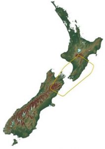
The area inside the yellow box in the map below indicates the area of the earthquake forecasts that we refer to in this story. Our best estimate is a 6% (very unlikely) chance, which is about a 1 in 16 chance. This has decreased over the last year (in December 2016 it was greater than 20% within the next year), but it is still a higher chance than before the 2016 Kaikōura earthquake.
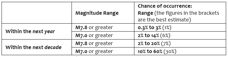
The table below shows the estimated chance of large earthquakes within the next year, and within the next 10 years. For example, within the next 10 years, there is a 10% to 60% chance (best estimate is 30%, unlikely) of a magnitude 7 or higher earthquake occurring in the area shown on the map (the map below shows what we mean by central New Zealand).
Updated probabilities table for central New Zealand.
The magnitude ranges are for a magnitude 7.8 or greater and magnitude 7 or greater within the next year and within the next 10 years.
How did we come up with these numbers?
Scientists from Japan, Taiwan, and USA met with our scientists to estimate the chance of a large earthquake occurring in central New Zealand. Together they assessed all the earthquake models, plus newly developed models of how slow slip events impact the probability of future earthquakes.
The results of these models were then combined with other information, including observations of how the numbers of earthquakes change during slow slip events, and evidence of earthquake clustering over the past few thousand years to estimate revised probabilities for large events in central New Zealand.
How does this forecast compare to before the Kaikoura earthquake?
The best estimate over the next year for a magnitude 7.0 or higher earthquake is 6%. This is an increase of 20% over the long-term estimates from the National Seismic Hazard Model (i.e., it is 1.2 times higher).
The best estimate for a magnitude 7.8 and higher earthquake is 1% within the next year. This is double the long-term estimates (i.e. it is twice as likely to happen now as it was before November 2016). The upper bounds for both magnitude range estimates are much higher than the long-term estimates.
That being said, the chance of a very big earthquake has been going down over the past year, since we first estimated the numbers following the Kaikoura earthquake.
Back in December 2016, there was a 5% chance of a M7.8+ earthquake within the coming year (December 2016 to November 2017), now the best estimate is 1% within the next year (December 2017 to November 2018).
This exercise has been focused on earthquake forecasts for larger magnitude earthquakes over central New Zealand rather than the Kaikōura aftershock sequence- (those will still be regularly updated here).
Science contact: Matt Gerstenberger m.gerstenberger@gns.cri.nz.
Science input received from Matt Gerstenberger and Sally Potter (GNS Science) as well as valuable contributions from our colleagues at MCDEM and USGS This research was funded by the Natural Hazards Research Platform Kaikoura Earthquake short term research projects.
About the author/s

Paul Somerville
Paul is Chief Geoscientist at Risk Frontiers. He has a PhD in Geophysics, and has 45 years experience as an engineering seismologist, including 15 years with Risk Frontiers. He has had first hand experience of damaging earthquakes in California, Japan, Taiwan and New Zealand. He works on the development of QuakeAUS and QuakeNZ.