The Great 1923 Kanto (Tokyo) Earthquake: a Fateful Forecast
- Briefing Note 491
Professor Omori and Associate Professor Imamura of Tokyo University
In 1899, in anticipation of the theory of plate tectonics that evolved in the 1960’s, Associate Professor Akitsune Imamura of Tokyo University argued that the tsunami that struck the Sanriku coast of Tohoku, northeast Japan, in 1896 had been triggered by movements of the Earth’s crust under the sea. The 1896 Mw 8.5 Sanriku earthquake generated tsunami waves that destroyed about 9,000 homes and caused at least 22,000 deaths.
In a magazine article written in 1905, Imamura forecast that a major earthquake would strike the Kanto region within half a century, and that it would be followed by a “general conflagration” that could kill 100,000 people should the fire protection system remain unimproved. When his forecast was reported in newspapers in a sensational way in early 1906, his senior colleague Professor Fusakichi Omori and other scientists denounced and discredited Imamura’s warnings, accusing him of scaremongering and causing social unrest. When a swarm of earthquakes occurred in Chiba, just northeast of Tokyo, in 1912, Imamura renewed his forecast and was further reprimanded and ostracized by Omori.

The occurrence of the Great Kanto Earthquake
The earthquake that struck the Tokyo region two minutes before noon on 1 September 1923, one hundred years ago, was so powerful that it drove Imamura’s seismograph off scale (right side of Figure 1). Over almost two days, fires triggered by household gas burners, chemicals and overhead wires raged through the wooden buildings of eastern Tokyo’s low-lying neighbourhoods. By the time the blazes had been extinguished or burned themselves out, an estimated 105,000 people were dead or missing, 90% due to the fire, and most of the city’s buildings had been destroyed, including 290,000 homes. The damage was estimated at ¥5.5bn, equivalent to 37% of Japan’s gross domestic product and four times the national budget at the time.
In Yokohama, Otis Manchester Poole wrote that “in contrast to other temblors that allowed time for contemplative speculation (“How bad is this one going to be?”) … This time … there was never more than a few moment’s doubt; after the first seven seconds of subterranean thunder and creaking spasms, we shot right over the border line. The ground could scarcely be said to shake; it heaved, tossed and leapt under one” (Hough and Bilham, 2020). This description is consistent with the nine minutes of off-scale motion recorded on the Imamura seismograph in Tokyo before its truncation shown on the right panel of Figure 1.
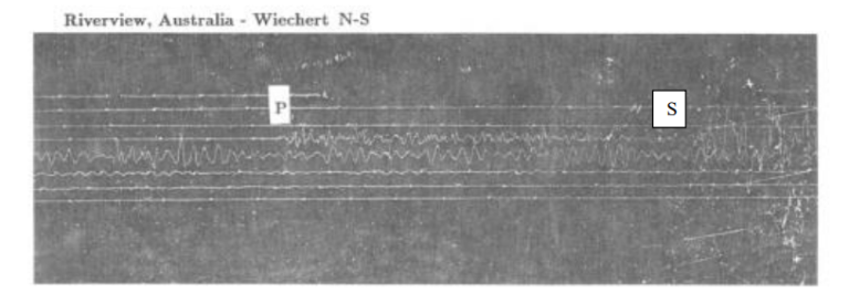
Omori was attending the second Pan-Pacific Congress in Australia when the earthquake occurred. As recounted by Aki (1980) and Wald and Somerville (1995), Omori was visiting the Riverview Seismographic Station in Sydney and witnessed the arrival of the seismic waves from the 1923 Kanto earthquake on the seismogram (Figure 2). The first arrival is the P (compressional) wave, which lies beneath the “P” marked on the seismogram. By measuring the time difference of about 9.5 minutes between the P wave arrival and the S (shear) wave arrival, he could tell that the earthquake had occurred about 7,800 km away, consistent with it having occurred in Tokyo.

During the course of his return to Japan by ship, Omori became ill and briefly lost consciousness; he was diagnosed as having a brain tumor. Upon his return to Japan on October 4, 1923, Omori was immediately hospitalised, and he died on November 8, 1923.
Cause of the Great Kanto Earthquake
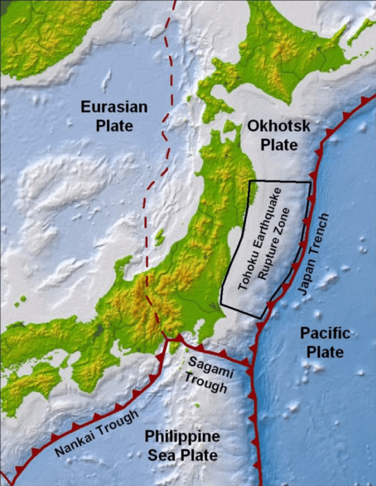
The great Mw 8.0 Kanto earthquake of 1923 was caused by the relative motion between the Okhotsk plate, on which northern Japan is located, and the Philippine Sea plate, which is subducting below the Okhotsk plate along the Sagami Trough located south of Tokyo, as shown in Figure 3. The northern edge of the Izu Peninsula, located at the northern tip of the Philippine Sea plate, is colliding with the Okhotsk plate, bringing the subduction plate interface onshore, a very rare condition. Subduction plate interfaces are generally confined to offshore regions as shown, for example, in the case of the Mw 9.0 2011 Tohoku earthquake (Risk Frontiers Briefing Notes 228, 217 and 437), which ruptured a segment of the interface between the Okhotsk and Pacific plates off the coast of northern Japan (Figure 3) that extends about 500 km along the coast and 200 km downdip from the Japan Trench to the coast.
The fault rupture surface of the great Kanto earthquake, shown by the dashed rectangle on the left side of Figure 4, lies at a depth of 2 km along its top edge along the Sagami Trough and at a depth of 32 km along its bottom edge beneath Tokyo. There were two patches of large slip on the fault, with maximum fault displacements of 8 m and 6 m. The geodetically measured horizontal ground displacements caused by the earthquake, shown on the right side of Figure 4, reached 3 m. These large displacements explain why the Imamura seismograph in Tokyo was driven off scale (right panel of Figure 1), and why Otis Manchester Poole wrote that the ground “heaved, tossed and leapt” under him in Yokohama, which is located halfway between Tokyo and Kamakura.


Basis of Imamura’s Forecast of the Great Kanto Earthquake
In an article in Taiyo magazine in 1905, Imamura noted that Tokyo had historically been struck by large earthquakes every 100 years on average, and that the last one was 50 years ago, so that another large earthquake could be expected to strike Tokyo in the next fifty years. He stated that the earthquake would be followed by a “general conflagration” that could kill 100,000 people should the fire protection system remain unimproved, and advocated that Tokyo should prepare appropriately. This article did not provoke undue controversy, but in January 1906, several newspapers reported Imamura’s arguments in a more sensational way. Omori wrote and published an article in Taiyo magazine denouncing Imamura’s work as propagating unfounded rumors. Omori was probably justified in pointing out that Imamura did not have a long enough time series to make a statistically significant inference of the recurrence time of earthquakes in Tokyo, and the forecast time window of 50 years was quite wide (Geller, 2023). Nevertheless, Imamura was closer to understanding the underlying causes of destructive earthquakes in Japan, and gained popular acclaim for his foresight following the occurrence of the 1923 earthquake.
Future Earthquakes Beneath Tokyo
In a review of earthquake probabilities in the Southern Kanto District following the occurrence of the 2011 Mw 9.0 Tohoku earthquake off northeastern Japan (Figure 3), it was found that the Tohoku earthquake is thought to have reduced the stress on the interface between the Philippine Sea plate and the Okhotsk plate on which the 1923 earthquake occurred (Somerville, 2014), and this plate interface is not currently a focus of major concern regarding future earthquakes in Tokyo.
As described by Satake (2023), the largest historically recorded earthquake in the Kanto District was the 1703 Genroku earthquake, which is thought to have occurred on the Sagami Trough, rupturing a fault plane that included the 1923 fault plane and an adjoining segment of the plate interface lying to its east, with a magnitude of about Mw 8.3. Other large earthquakes are thought to have occurred on the Sagami Trough in 878, 1293, 1430 and 1495, indicating an irregular recurrence interval of about 200 years for large earthquakes on the Sagami Trough. Looking further back in time using geological markers such as marine terraces, beach ridges and tsunami deposits, Shishikura (2014) found that at least 16 large earthquakes have occurred on the Sagami Trough in the past 7,500 years, indicating an irregular recurrence interval of about 500 years.
The aperiodic nature of these events makes forecasting them very uncertain. Despite the revolution in our understanding of the causes of earthquakes based on plate tectonics, and the best efforts of seismologists in Japan and around the world in the hundred years since the 1923 earthquake, seismologists have not greatly improved their ability to forecast individual earthquakes, and the ability to predict the location, time and magnitudes of earthquakes within useful ranges does not exist.
The Japanese Prime Minister’s Cabinet Office (2013) estimated that a repeat of the Mw 8 1923 Kanto earthquake would produce 70,000 deaths and 1,330,000 damaged buildings for a worst-case scenario. Corresponding estimates by the Tokyo Metropolitan Government (2022) yield 1,800 deaths (1,200 from ground shaking and 600 from fire), and 55,000 damaged buildings (about equally divided between ground shaking and fire). It is unclear why the Cabinet Office estimates are so much higher than the Tokyo Metropolitan Government estimates.
In addition to these large earthquakes, smaller earthquakes having magnitudes of about Mw 7 are known to occur about once every 30 years in the southern Kanto District, giving a 30-year probability of occurrence of Mw ~7 events of about 70% (ERC, 2014).
Cabinet Office (2013) estimates for a M ∼7 earthquake are 23,000 deaths and 610,000 damaged buildings, about half those of the repeat of the 1923 earthquake, as would be expected from the lower magnitude. However, corresponding estimates by the Tokyo Metropolitan Government (2022) yield 6,100 deaths and 194,000 damaged buildings (82,000 from ground shaking and 112,000 from fire). It is unclear why the Tokyo Metropolitan Government estimates for the M ~ 7 earthquake are about 3.5 times higher than for a repeat of the M ~ 8 1923 event. The Tokyo Metropolitan Government is evidently prioritizing preparation for the M ~ 7 event because it is both more likely to occur and is expected by them to cause more damage than a repeat of the M ~ 8 1923 event.
The Cabinet Office (2013) estimates direct damage reaching ¥47tn ($AUD 517bn) for the M ~ 7 event. This is nearly three times larger than the ¥16.9tn ($AUD 188bn) direct loss in the 2011 Mw 9 Tohoku earthquake, which is the largest known natural disaster loss in history. Widespread disruption to manufacturing and services caused by damage to transport networks and power cuts could reach a similar amount, along with price increases and an unstable yen. The Tokyo Metropolitan Government (2022) estimates that about 4.53 million people of the total population of 37.27 million (about 12%) would be unable to return home in the aftermath of the earthquake.
Proximity of the Hikurangi Plate Interface to the central New Zealand East Coast
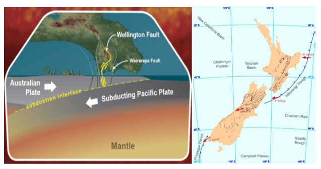
As noted above, Tokyo is located directly above the shallow plate interface between the Okhotsk and Philippine Sea plates that is expressed on the seabed by the Sagami Trough. A similar condition is present in Wellington (Figure 5), where the Hikurangi Trough, which lies off the east coast of the north island of New Zealand, comes close to shore as it transitions to a shallow strike-slip plate boundary on the Alpine Fault which runs along the west coast of the South Island. The transition occurs south of Wellington on a complex set of faults in the northeast corner of the South Island, including the faults that ruptured in the 2016 Mw 7.8 Kaikoura earthquake (Risk Frontiers Briefing Notes 330 and 332). As shown on the left side of Figure 5, Wellington is located at a depth of about 32 km above the Hikuragi subduction plate interface. This is comparable to the proximity of the rupture zone of the Mw 8.0 1923 Kanto earthquake to Tokyo.
The Challenge of Earthquake Preparedness
The centenary of anniversary of the great Mw 8.0 Kanto earthquake in Tokyo presents a reminder of the huge scale of large earthquake disasters and their potential to change the course of history, as occurred in Japan following that event. For example, Hammer (2011) wrote that “The powerful quake and ensuing tsunami that struck Yokohama and Tokyo traumatized a nation and unleashed historic consequences.” The centenary also provides a reminder of the huge challenge of planning for emergency response and recovery, which is essential for maintaining continuity following major earthquakes, especially in national capitals such as Tokyo and Wellington.

References
Cabinet Office (2013). On the damage estimation and countermeasures or the earthquake beneath Metropolis: Appendix 1 of final report (Quantitative estimation of material and human damage) (in Japanese), 41 pp., available at https://www.bousai.go.jp/jishin/syuto/taisaku_wg/pdf/syuto_wg_siryo01.pdf
Earthquake Research Committee (ERC) (2014). Long-term evaluation of seismicity along Sagami Trough (2nd version) (in Japanese), Headquarters for Earthquake Research Promotion, 83 pp., available at https://www.jishin.go.jp/main/chousa/kaikou_pdf/sagami_2.pdf
Geller, R. (2023). The Imamura vs. Omori Earthquake Forecasting Debate. The Asia-Pacific Journal, Japan Focus. Volume 21 | Issue 8 | Number 5 | Article ID 5787 | Aug 30, 2023
Hammer, Joshua (2011). The Great Japan Earthquake of 1923. https://www.smithsonianmag.com/history/the-great-japan-earthquake-of-1923-1764539/
Hough, Susan Elizabeth, and Roger G Bilham, ‘The 1923 Kanto Earthquake: Surviving Doomsday’, After the Earth Quakes: Elastic Rebound on an Urban Planet (New York, 2005; online edn, Oxford Academic, 12 Nov. 2020), https://doi.org/10.1093/oso/9780195179132.003.0010, accessed 11 Sept. 2023.
Risk Frontiers (2011a). The Mw 9.0 Tohoku, Japan Earthquake of 10 March 2011. Risk Frontiers Briefing Note 217.
Risk Frontiers (2011b). Recovery from the 2011 Tohoku, Japan Earthquake and Tsunami. Risk Frontiers Briefing Note 228.
Risk Frontiers (2016a). The Mw 7.7 November 14, 2016 Kaikoura Earthquake, Briefing 1. Briefing Note 330.
Risk Frontiers (2016a). The Mw 7.7 November 14, 2016 Kaikoura Earthquake, Briefing 3. Briefing Note 332.
Risk Frontiers (2021). Ten years after the 2011 Tohoku, Japan Earthquake and Tsunami. Risk Frontiers Briefing Note 437.
Satake, K. (2023). Recurrence and long-term evaluation of Kanto earthquakes, Bull. Seismol. Soc. Am. doi: 10.1785/0120230072.
Shishikura, M. (2014). History of the paleo-earthquakes along the Sagami Trough, central Japan: Review of coastal paleo-seismological studies in the Kanto region, Episodes 37, 246–257, doi: 10.18814/epiiugs/2014/v37i4/004.
Somerville, P.G. (2014). A post-Tohoku earthquake review of earthquake probabilities in the Southern Kanto District, Japan. Geosci. Lett. 1, 10 (2014). https://doi.org/10.1186/2196-4092-1-10.
Tokyo Metropolitan Government (2022). Report of damage estimation for earthquakes beneath Tokyo (in Japanese), 475 pp., available at https://www.bousai.metro.tokyo.lg.jp/_res/projects/default_project/_page_/001/021/571/20220525/n/002n.pdf
Wald, D. J., and P. G. Somerville (1995). Variable-slip rupture model of the great 1923 Kanto, Japan, earthquake: Geodetic and body-waveform analysis, Bull. Seismol. Soc. Am. 85, 159–177.
About the author/s

Paul Somerville
Paul is Chief Geoscientist at Risk Frontiers. He has a PhD in Geophysics, and has 45 years experience as an engineering seismologist, including 15 years with Risk Frontiers. He has had first hand experience of damaging earthquakes in California, Japan, Taiwan and New Zealand. He works on the development of QuakeAUS and QuakeNZ.
