The 2023 Update of the Australian National Seismic Hazard Assessment (NSHA23)
- Briefing Note 501
The 2023 Update of the Australian National Seismic Hazard Assessment (NSHA23) was released on 17 March 2024, and documented by Allen et al. (2023; 2024); Clark et al. (2023), and Geoscience Australia (2023). The previous update in 2018, named NSHA18, yielded major reductions in hazard levels compared with the 2012 update (NSHM12, Burbidge et al., 2012). That occurred because NSHM12 did not correct local magnitudes ML or convert them to moment magnitudes Mw. NSHA18 made those corrections, resulting in large reductions (in the range of 1/2 or 1/3 in most locations). NSHA23 resulted in much smaller changes from NSHA18, with a moderate increase in most parts of eastern Australia.
Our Contributions to NSHA23
Earthquake Source Models: Jacob Evans of Risk Frontiers updated our spatially smoothed seismicity model, originally generated for NSHA18, for use in NSHA23. This model was used by Geoscience Australia, along with 11 other models, to generate the NSHA23 ground motion maps. In particular, it was used to compare the effect of introducing a truncation time window on the declustering method of earthquakes. This notion is discussed in more detail in the following section.
Ground Motion Models: The Somerville et al. (2009) ground motion models for Australia were updated. These models were used by Geoscience Australia along with 11 other models to generate the NSHA23 ground motion maps.
Truncated Declustering Time Window
The Australian continent has several examples where aftershock sequences may continue for decades following the original mainshock. For example, in 2019, a Mw 5.0 earthquake occurred in the vicinity of the 1988 Tennant Creek earthquake sequence in the Northern Territory. Taking the classical declustering approach and the revised Leonard (2008) declustering algorithm, this 2019 event would be removed from the catalogue for the purposes of estimating the earthquake rate model. Based on a fundamental assumption in probabilistic seismic hazard analysis (PSHA), this action is intended to remove the correlated events from the earthquake catalogue. PSHA assumes earthquake events are independent of each other and follow a Poissonian distribution. However, these “aftershocks” still pose a risk to new construction and the existing built environment.
NSHA23 introduced a truncated declustering time window which has a specific duration after which earthquakes that are associated with an enduring aftershock sequence may be treated as independent events for the purposes of seismic hazard assessment. This is a pragmatic decision that is intended to re-introduce seismic moment into regions that may have been affected by large historical earthquakes and continue to experience aftershocks, but by using declustering methods without a truncation time window the seismic moments resulted from recent earthquakes are removed from the seismic source models.
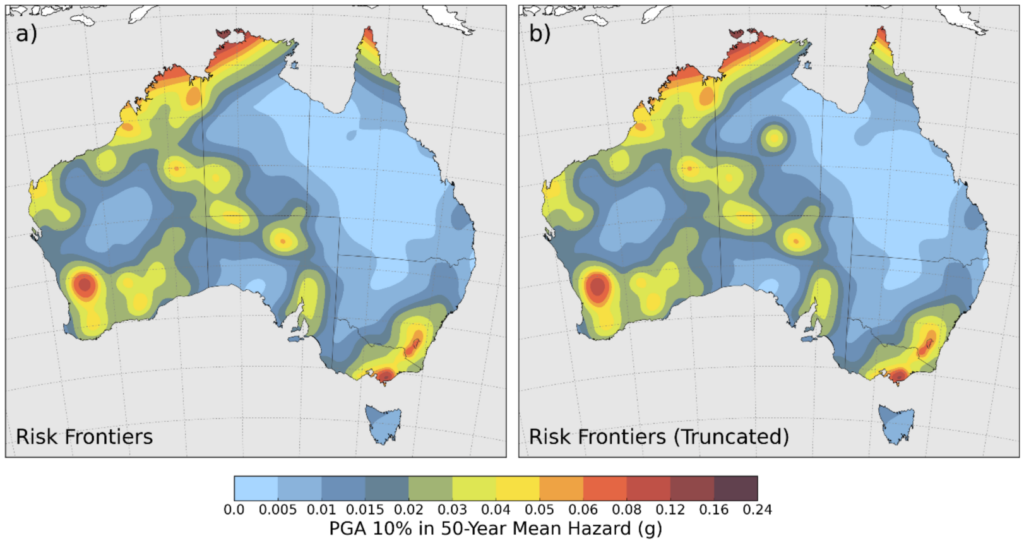
For the 1988 Tennant Creek sequence, classical declustering techniques effectively reduce the number of earthquakes in this area to a single event: the Mw 6.6 mainshock on 22 January 1988. By contrast, the truncated approach accepts independent events that occur outside of the truncation time window, to contribute to the seismic rate model, and consequently seismic hazard. This approach is not expected to have significant effects on the determination of earthquake rates for zone-based source models. However, it will affect the hazard forecasts for smoothed seismicity models. As an example, Figure 1 shows a comparison of the Risk Frontiers smoothed seismicity model applying the full declustering and truncated declustering approach with a maximum time window of 10 years, which produced moderate increases in seismic hazard in the Tennant Creek region of the Northern Territory.
Results
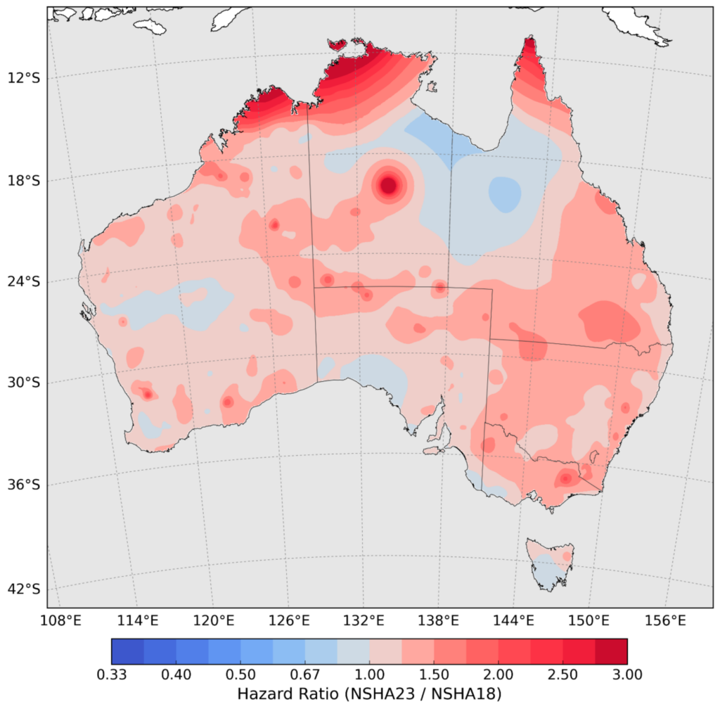
The NSHA23 hazard maps resulted in mostly moderate increases in comparison to its predecessor, NSHA18. Changes in seismic source characterisation led to slight decreases in hazard, and changes in ground motion models led to consistently higher hazard in most places, with a net effect of a moderate increase in Eastern Australia (Figure 2). The main difference in hazard estimates is for sites in northern Australia that are affected by large plate-boundary earthquakes occurring in the Banda Sea region. At these sites, the mean PGA hazard has approximately doubled over a range of exceedance probabilities, as shown in Figure 2.

Comparison of Response Spectra in the Capital Cities
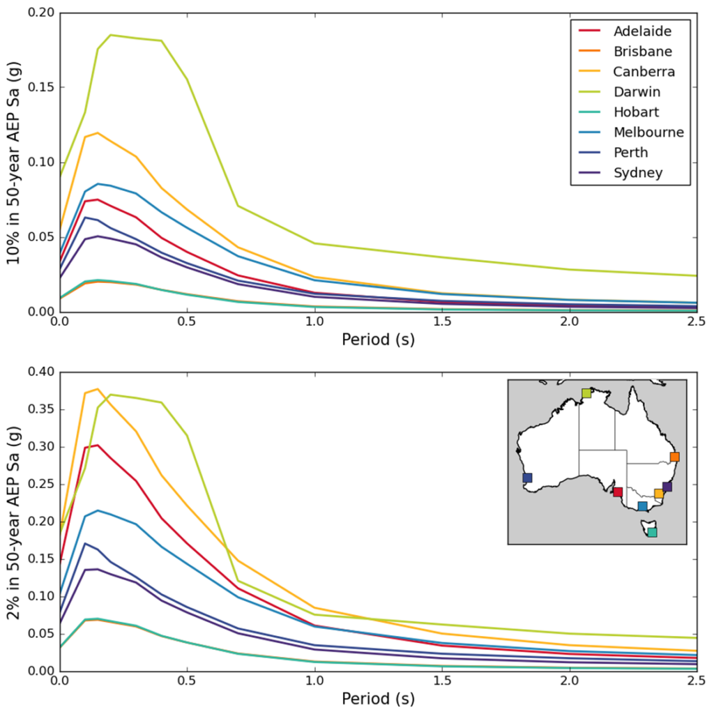
The response spectra in the capital cities for Annual Exceedance Probability (AEP) of 1/475 and 1/2,475 are shown in Figure 3. The peak ground acceleration (PGA) is given by the response spectral value for zero period (left hand vertical axis). For the AEP of 1/475 the peak ground accelerations, from largest to smallest, are for Darwin, Canberra, Melbourne, Adelaide, Perth, Sydney, Hobart and Brisbane (the latter two overlap). The main difference between the AEP of 1/2475 and 1/475 is the elevated spectral acceleration (Sa) of Adelaide over Melbourne in periods of 0.0 to 1.0 seconds and the lowered relative Sa of Darwin compared to Canberra in that period range.
Building Code (AS1170.4) Ground Motion Map
Modern seismic hazard assessments for Australia suggest that some regions are characterised by very low earthquake activity rates and, consequently, by low probabilistic hazards. In these locations, designing structures based on probabilistic seismic hazard levels is unlikely to provide adequate protection to buildings and their occupants in the event of a strong earthquake. This indicates the underlying motivation for the introduction of a floor hazard level to provide a minimum level of protection to structures.
The previous version of the Australian Standard AS1170.4 – 2007 ground motion map, AS1170.4 Amendment 2 (2018), shown on Figure 4a, contains a floor (minimum) PGA of 0.08g for reference site conditions (Vs30 of 760 m/s). As shown in this figure, only a small portion of Australia’s total area exceeds this floor level. By using the floor, in many parts of Australia, the ground motion map represents ground motions having an AEP far below the standard notional level of 1/475. This excessive safety margin is especially evident in the eastern parts of Australia, which have lower seismic hazards. This difference is shown on the Figure 4b, which is a map of the probability of exceeding 0.08g in 50 years based on NSHA18. The 10% level (red) corresponds to the notional code level, and most of Australia is well below that level.
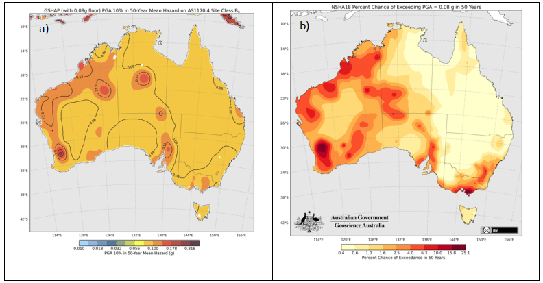
The AS1170.4 2024 revision (AS1170.4:2024, released on 21 June 2024) retains the peak acceleration map from AS1170.4:2007 Amendment 2 (2018) shown in Figure 4a and makes no reference to NSHM12, NSHA18 or NSHA23. The AS1170.4:2024 building code map, which has a PGA of 0.08g as its floor value, still prescribes ground motions with far lower AEPs than 1/475 in most locations in Australia.
Implications for Building Code Ground Motion Levels for Insurance
While the use of a floor for seismic hazard levels might be justified for building code applications, it is not appropriate for probabilistic hazard and loss modelling for insurance. For that purpose, the probabilistic model used in developing the NSHA23 should be used. However, it needs to be borne in mind that historically, AS1170.4 has overestimated the hazard levels in most locations and continues to do so. The implication of this situation is that, in places where the imposed floor seismic hazard level exceeds the actual value, as estimated in NSHA23, code-based structures are designed for hazards with a lower AEP than 1/475 i.e. using higher hazard levels, and therefore they may be less vulnerable to earthquakes than assumed in AS1170.4.
QuakeAUS – Risk Frontiers’ Probabilistic Seismic Loss Model
Risk Frontiers’ fully probabilistic detailed loss model for Earthquake, QuakeAUS, now at Version 6, uses NSHA18 as a basis for hazard. It includes an active fault model, updated soil classification and uses ground motion prediction models developed specifically for Australia by Somerville et al. (2009). An update of QuakeAUS incorporating NSHA23 is currently under development and will be released in the near future.
References
Allen, T., J. Griffin, D. Clark, P. Cummins, H. Ghasemi and R. Ebrahimi (2023). The 2023 National Seismic Hazard Assessment for Australia: Model overview. Record 2023/53. Geoscience Australia, Canberra.
Allen, T., J. Griffin, D. Clark, and T. King (2024). The 2023 National Seismic Hazard Assessment for Australia: Model Input and Output Data. Record 2024/10. Geoscience Australia, Canberra.
Allen, T. (2018). Proposed updates to Geoscience Australia’s National Seismic Hazard Assessment. 17 April 2018: NSHA18 Insurance Industry Briefing.
Burbidge, D. R. (ed.), The 2012 Australian Earthquake Hazard Map, GA Record 2012/71.
Clark, D. J. (2023). The 2023 National Seismic Hazard Assessment for Australia: notes on fault parametrisation for the fault-source model, Geoscience Australia Record 2023/54, pp 47, doi: 10.26186/149143.
Geoscience Australia (2023). https://data.gov.au/dataset/ds-ga-86d9ffcf-8bbf-4aad-b6c4-70fcae2be457/details?q=
Leonard, M. (2008). One hundred years of earthquake recording in Australia, Bull. Seismol. Soc. Am. 98, 1458–1470, doi: 10.1785/0120050193.
Somerville, P.G., R.W. Graves, N.F. Collins, S.G. Song, S. Ni and P. Cummins (2009). Source and ground motion models of Australian earthquakes. Proceedings of the 2009 Annual Conference of the Australian Earthquake Engineering Society, Newcastle, December 11-13.
Standards Australia (2007). AS 1170.4—2007. Structural design actions Part 4: Earthquake actions in Australia.
Standards Australia (2018). Amendment No. 2 to AS 1170.4—2007. Structural design actions Part 4: Earthquake actions in Australia.
Standards Australia (2024). AS 1170.4—2024. Structural design actions Part 4: Earthquake actions in Australia.
About the author/s

Paul Somerville
Paul is Chief Geoscientist at Risk Frontiers. He has a PhD in Geophysics, and has 45 years experience as an engineering seismologist, including 15 years with Risk Frontiers. He has had first hand experience of damaging earthquakes in California, Japan, Taiwan and New Zealand. He works on the development of QuakeAUS and QuakeNZ.

Jacob Evans
Jacob has been involved in the development of our FloodAUS, CyclAUS and QuakeAUS Cat-Loss models. He specialises in data science and mathematics.
Jacob received his PhD in Condensed Matter Physics from Macquarie University. Jacob’s interests include data science, numerical modelling, physics and mathematics.
Joining Risk Frontiers in 2017, Jacob has worked across a range of projects from model development and climate risk management to resilience and portfolio modelling.
Notably, Jacob has employed techniques such as machine learning and statistical analysis to understand the vulnerability of risk across Risk Frontiers catastrophe suite, as well as applying machine learning algorithms for flood, cyclone and earthquake models. He also works on hazard and loss modelling.

Behnam Beheshtian
Behnam is a Risk Engineer at Risk Frontiers, responsible for developing and maintaining the QuakeAUS and QuakeNZ models, in addition to contributing to the development of other models within the group.
He is passionate about researching the risk and resilience of the built environment in the face of natural hazards, including earthquakes, tsunamis, and bushfires. Holding a bachelor’s in civil engineering, along with his industry experience, means he is well-versed in the structural design of a wide variety of commercial, industrial, and infrastructure projects. Behnam’s PhD is in Earthquake Engineering from Swinburne University of Technology, where he researched the risk and resilience of the built environment to tsunami and seismic hazards.
