Between March 18 – 23, 2021, extreme rainfall caused by a low pressure trough off Australia’s eastern seaboard resulted in severe flooding in many parts of New South Wales. Many of Sydney’s catchments received in excess of 250 mm of rain in the period, including the Hawkesbury River in Sydney’s northwest. The Hawkesbury River sits below Sydney’s primary water storage, Warragamba Dam, and has a long history of flooding events. The Warragamba catchment stretches from north of Lithgow at the head of the Coxs River in the Blue Mountains to the source of the Wollondilly River west of Crookwell, and south of Goulburn along the Mulwaree River[1].
Penrith experienced flooding with an estimated average recurrence interval of once every 20 years and North Richmond and Windsor, flooding with an average recurrence interval of once every 10-20 years[2]. The unusual terrain of the Lower Hawkesbury and tributaries has been described as “a bathtub with five taps on and only one plug hole”. Further contributing to flood risk is that the area also has a constrained evacuation road network and low levels of community flood awareness[3].
In the early 1950s, many reaches on the Lower Hawkesbury began to see the emergence of water ski parks on the banks and floodplains of the river as the sport rapidly grew in popularity[4]. In time, many of these parks evolved to become caravan / ski parks (hereafter referred to as ‘parks’) to meet the needs of skiers and other holiday makers. Many of the worst-impacted areas were those containing these parks and are the focus of this briefing note.
Overview
On April 14, Risk Frontiers visited the Lower Hawkesbury region of Western Sydney to observe and report on the impacts of significant flooding in the area with a focus on caravan / ski parks. Parks were surveyed at Windsor, Sackville, Wisemans Ferry, Wilberforce, Pitt Town and Lower Portland (Figure 1).

The survey team visited nine parks, investigating flood warnings, evacuation and aspects of flood emergency plans, and assessing damages and building resilience against future flooding. Of those parks visited, several permitted permanent residents. Of these, one reported that many permanent residents had lost everything. This park, catering exclusively to permanent residents, was forced to close under a Public Health Order due to damaged sewerage infrastructure. Park operators reported that permanent residents forced to relocate had either been provided emergency temporary housing or were staying with friends and relatives.
All other park operators were quick to establish that no permanent residents were permitted to live on site, though all parks do have a permanent caretaker or manager living at the location. These parks are zoned as temporary or holiday accommodation where tenants either pay an annual fee for a cabin or leave a van parked on site and stay for short periods. Ultimately, the responsibility of removing caravans rests with their owners. Several site managers, however, reported assisting with securing tenants’ possessions and / or vans (anchoring them to slabs) or towing them to higher ground by tractor if requested.
A number of key issues emerged, including:
- Scale of damage and uninsurability: Many owners / managers indicated that, due to the location of parks, flood insurance was either unaffordable or not available, reflecting the flood risk exposure of park locations. The subsequent damage bills for a few parks may prevent their reopening.
- Evacuation warnings: Some operators reported warnings with unclear instructions received by several different methods including email, text message and social media. Park operators were reliant on warnings to activate their emergency plans.
- Flood warnings relating to spills from Warragamba Dam: Many park operators felt that pre-releases of water from Warragamba should have occurred to reduce the flood peak and subsequent damage. A number of operators found it difficult to get information as to when the dam would spill.
- The perceived ‘too early’ closure of the Windsor Bridge: This was perceived as a significant factor which prevented some caravan owners attending parks to secure their possessions.
Impacts
Peak heights
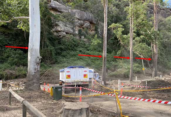
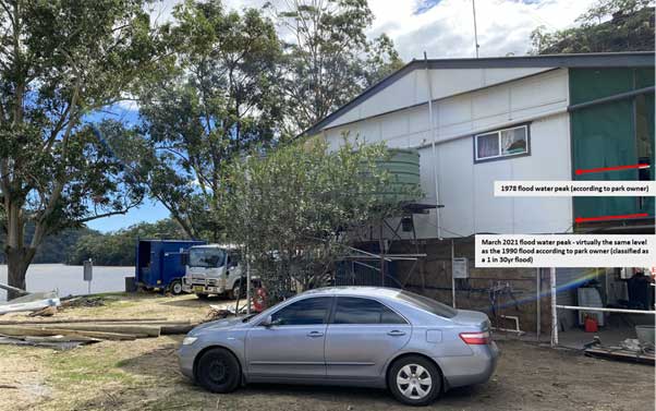
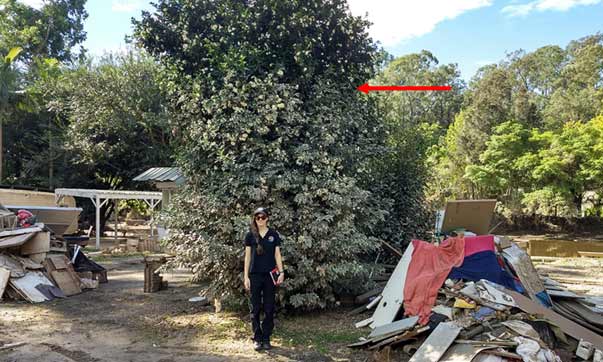
The confined setting of many of the park locations was a major contributor to the peak flood heights. Parks situated in narrower reaches where flood waters were confined by valley walls (Figures 2,3 and 4) were those where the highest flood peaks of > 3 metres occurred. At one park, near Lower Portland, the peak flood height was clearly evident on trees where stripped bark and deep scratches scarring tree flanks was caused by fast moving debris which had impacted the trunks, as shown in Figure 2.
The owner of this park reported that this flood’s peak level was virtually identical to the 1990 event as seen on the park manager’s residence (Figure 3).
Floodwaters entering caravans, cabins and annexes in other areas visited caused the almost total destruction of all furniture and possessions inside including white goods, bedding, flooring, furniture, walls and skirting boards. At all locations visited, vast piles of destroyed property awaited removal.
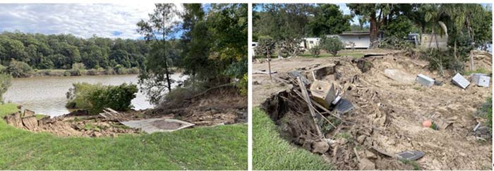
Bank erosion and destabilisation
A number of parks exhibited significant erosion of banks. One park in particular exhibited major bank collapses which had consumed structures and other property (Figure 5). Much of this was swept away downstream or deposited in other parts of the park. Most eroded areas remained cordoned off due to the continuing bank instability. The manager of this park (in Figure 5) expressed great concern that, even if the owners could meet the costs of park / infrastructure damage, the expense of earthworks to fortify the banks would pose an enormous barrier preventing reopening in the foreseeable future, if at all.
Vast volumes of debris
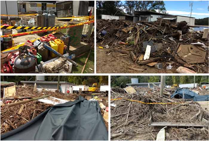
The majority of the parks visited reported significant destruction to park infrastructure and / or tenants’ caravans, portable homes, cabins and annexes. The owner of one park reported that an estimated 4,500 cubic metres of debris had been left behind by receding flood waters. Deposited refuse included roofing and fencing, park benches and garden furniture, road signs as well as gas bottles, fuel drums and containers (Figure 6). The size and weight of many of these items – enormous tree stumps in particular – caused considerable secondary damage by colliding with other structures and dislodging them into the floodwaters. A number of caravans from other parks were also deposited here, including one from over 40 km upstream. This park owner reported that the estimated bill would be in excess of $1 million – should the owner have to meet the cost of removal of the debris from this one site.
Damage estimates and park closures
Damage estimates provided by park operators varied greatly. This is partly due to the range of park sizes (from 23 to > 140 sites), although other factors, including flood planning (discussed in a later section), had significant influence on losses experienced.
The lowest loss figure provided was between $5k – 10k (uninsured) for a park that lost only the individual power boxes servicing each van site. Grants would likely meet the cost of repairs. No vans were lost and this park did not close. Key to this outcome, as reported by the park owner, was early intervention, which allowed the safe relocation of all the park’s vans.
At the other end of the scale were two parks in particular which estimated far more significant losses. One park estimated that the uninsured damage bill would likely exceed $400K (Figure 6), whilst another estimated damages far in excess of $1 million (Figure 4). This park manager expressed resignation that the park may not reopen at all. A number of park operators perceived the early closure of bridges in the area, most notably the Windsor Bridge (closed on Sunday 21 March), as a significant factor in preventing park tenants from attending parks to secure their property.
Most other parks estimated damages from $100k – $200K, with likely closure times estimated at between 2 or 3 weeks to 4 months.
Warnings
Many park operators were critical of the methods and timing of warnings they received in the lead-up to flooding. Key concerns associated with warnings were:
- Warning method – Most park managers said that warnings were commonly received via email, though others also received information and updates from the SES via text messages. At a time when managers were under significant time pressures and stress, the need to receive accurate and early information in a fast and simple format was thought not be available to them to make crucial decisions such as activating flood plans.
- Warragamba water spill – Many park operators said they did not receive enough information about the time of the spill from Warragamba Dam. Some felt that the impact of the spill on flood intensity had been underestimated in warnings they received.
- Past flood warning inconsistencies – Over-estimations of past flood intensity were reported by several park operators as contributing to a desensitisation of some people in the community to the risks posed in flood warnings on this occasion.
Current Policy and Regulations
The development and operation approval process for caravan parks in NSW is governed by the Environmental Planning & Assessment Act 1979 (EP&A Act) [5]and section 68 of the Local Government Act 1993 (LG Act)[6]. The Local Government (Manufactured Home Estates, Caravan Parks, Camping Grounds and Moveable Dwellings) Regulation 2005[7]also contains provisions that provide a means to highlight flood risk within a locality such as:
- The location of any flood liable land to be marked on a community map (available to park patrons)
- The community map to be displayed in a prominent position in the caravan park / camping ground
- The operator to inform prospective occupants of short term / camping sites about the location of flood-liable land.
Most caravan / ski parks’ development consent and emergency planning is regulated at the local council level.
Emergency Planning – Flood Emergency Management Plans (FEMPs)
While having a FEMP is not a requirement under NSW legislation, a flood plan for caravan parks is a requirement of local councils. All park operators spoken with insisted they had activated their parks’ flood plans at some point during the flood. Several factors relating to these flood plans and their activation have significantly influenced loss differences between parks. These include:
- Early intervention – Those park operators that activated their flood plan early – by contacting tenants to attend and secure vans and possessions and by moving vans to higher ground – experienced far less damage and losses than those that did not. Two park managers obtained additional information about the condition of Warragamba Dam after receiving ambiguous flood warnings. Neither park lost any caravans as a result. These experiences contrast with those of another park manager whose flood plan activation was reliant on adequate flood warnings. He attributes the ambiguity of information in delaying his actions and the closure of the Windsor Bridge as key factors in the massive damages his park sustained.
- Past experience with Hawkesbury flooding – Those park managers who had lived in the Hawkesbury area for longer periods highlighted a reluctance to rely on warnings of flooding and evacuation alone in activating their flood plans. Past experience (that Warragamba Dam automatically spills in response to flooding)[8], led to early contact of park tenants / van owners to attend and prepare for at least moderate flooding.
- Security of vans – At one park, the owner’s flood plan included bolting all caravans to their site slabs (Figure 7). No caravans were lost from this park: however, the contents of many were destroyed and semi-permanent annex structures attached to them were damaged or swept away. Another park owner reported dragging caravans by tractor, even those without towing couplings, to higher ground to prevent them being claimed by the flood.

Some Councils in NSW have implemented requirements for caravan parks regarding the development and regular updating of FEMPs in response to failures of some caravan park operators in past floods. Yeo et al (2016) recommends that similar requirements could be added as a condition of approval processes in the Local Government Act under sections 68 and 94 to address shortcomings in other flood prone council areas[9].
Conclusions
The field survey has supported previous research regarding the high risks posed to caravan parks and their occupants during flooding. Given the extent of damage observed, it is fortunate that relatively slow-rising flood waters and low occupancy rates at parks prevented any loss of life. Caravan parks located in flash flood prone areas would likely not have fared as well.
Ultimately, timely flood response to ensure safety and reduce damages is reliant on warnings. Flood emergency plans have shown some potential to limit impacts to people and property: however, this research has highlighted their limitations including their reliance on:
- the timely receipt and accurate interpretation of warnings
- vans being maintained in a condition that allows them to be moved
- van owners having safe access to remove vans and a ‘flood safe’ location for their storage.
This survey has demonstrated the continued need to engage with communities about flood warnings systems. Further social research in areas impacted by recent floods would assist in this process.
Risk Frontiers has recently undertaken another field survey to flood-impacted areas on the NSW mid North Coast. The report and findings are available in Briefing Note 440 – April 2021 at https://riskfrontiers.com/insights/
Acknowledgement
This research was supported by the Bushire and Natural Hazards Cooperative Research Centre.
[1] NSW Government -Environmental Planning & Assessment Act 1979 (NSW) (EP&A Act)
[2] Local Government Act 1993 (NSW) s 68 (LG Act)
[3] Local Government (Manufactured Home Estates, Caravan Parks, Camping Grounds and Moveable Dwellings) Regulation 2005
[4] Water NSW – Warragamba Dam – How the gates work. YouTube video. https://www.youtube.com/watch?v=1VFyKsrXKPk
[5] Water NSW – Warragamba Catchment overview. https://www.waternsw.com.au/water-quality/catchment/sub-catchment/warragamba.
[6] INSW – Resilient Valley, Resilient Communities Hawkesbury-Nepean Valley Flood Risk Management Strategy. http://insw.com/media/2857/hnv-march-2021-flood-faq.pdf
[7] NSW Government – Flooding in the Hawkesbury-Nepean Valley. insw-factsheet-flooding-in-the-hawkesbury-nepean-valley.pdf
[8] Ski Racing History – Region V. http://regionv.com.au/articles-pdf/SkiRacingHistory.pdf
[9] Yeo, S. and Marr, T., ‘Plans Schmans!’ (2016) –How Caravan Parks Responded To The August 2015 Sussex Inlet And Lake Conjola Floods. http://www.floodplainconference.com/papers2016/Stephen%20Yeo%20and%20Ailsa%20Schofield.pdf
About the author/s

Jonathan Van Leeuwen
Jonathan is a Research Analyst at Risk Frontiers. He has a BSc(Spatial Information Science) and engages with government, private sector and not-for-profit clients to provide physical and social research, data analysis and GIS solutions for natural hazard related risk management and resilience.