The Weather behind the Eastern Australian floods – the storm cluster from 23rd February to 2nd April, 2022
- Briefing Note 464
Flooding in late February, March and early April caused significant damage along large sections of the Australian east coast. Here we describe the weather driving these events and place them in some historical context.
Moderate to severe late summer flooding in eastern Australia is usually associated with the southward passage of tropical cyclones (TC) and lows (TL) making landfall and/ or transition to an East Coast Low (ECL) between Hervey Bay and Yamba. There are numerous analogues for these weather events including the 2011 and 1955 events. Forecasting rainfall intensity and spatial coverage during the decay of tropical cyclones and lows is dependent upon the track of the TC or TL, with the greatest uncertainty being the latitude of landfall. Such weather events provide communities and authorities time to prepare based on the probability of landfall location. They are also singular events that last 2-3 days but are typically part of a seasonal chain of TCs or TLs that track southwards in the Coral Sea during La Nina summers.
Similarly, the transition from inland troughs to the formation of ECL storms during the autumn – early winter seasons also are typical of Eastern Australian climate. However, the synoptic nature and the cluster of three storms causing extreme rainfall, flooding and complex impacts such as widespread landslides in the SE Queensland, Northern NSW and the Central to Illawarra Coasts is rare and requires analysis to place them in the historical and future climate context. This article investigates the meteorology and related impacts of the storm cluster in 3 phases beginning on the 23rd of February and finishing on the 2nd of April.
Storms 1 and 2
Two different storm events produced extreme flooding events from the 23rd of February to 9th of March, 2022. The weather was very different to that associated with the landfall or decay of TCs and TLs and involved the formation of a tropical dip that is an inland trough system extending from the tropics to the subtropics. During late January and February, the large-scale atmospheric circulation in the Australian and western Pacific Ocean region had been quasi-stationary for weeks from the tropics to Antarctica. That is, the weather map looked nearly identical every night in the news bulletins, with a deep-layered tropical inland trough over Queensland and a strong subtropical high over Victoria and New Zealand and extending to form a subpolar high over part of the Southern Ocean. It was this stationarity that led to a progressive cluster of extreme events from tropical heatwaves in mid February to tropical/ subtropical storms in Eastern Australia to the East Antarctic heatwave of mid March. Hence, it is necessary to view the extreme weather and flooding impacts over Eastern Australia in the context of this cluster of events. In addition, the extensive and record-breaking flooding occurred on the back of a strong wet season, with dams nearing capacity and high soil moisture, ensuring early run off.
Background climate drivers of the quasi-stationary weather
The Coral and Tasman Seas, together with the equatorial Indo-Pacific ocean to the north of Australia, were typically warm for La Niña and, in this case, a two-year back-to-back La Niña event. Near record sea-surface temperatures (SSTs) extended along the western Tasman Sea, particularly bordering the continental shelf off the Central to Illawarra Coast of NSW. This southward penetration of the East Australian Current warm core was due to strengthened Pacific tradewinds. Further to the south the subtropical high had expanded polewards from the mid-latitudes to form a subpolar high. This intensification of the high directed SE tradewind flow across the entire eastern seaboard and pushed the circumpolar westerlies closer to the Antarctic coast. In essence, this basic climatology was expected for a La Niña in the tropics to be paired with strengthened poleward westerlies and polar vortex associated with the coupled positive phase of the Southern Annular Mode (SAM) (see descriptions of Climate Drivers at www.bom.gov.au). In tropical Australia, intense solar heating formed a string of Heat Lows over the continent. This formed an inland trough system from SW Western Australia across the Northern Territory and southwards into Eastern Australia. Also, typical of La Niña years, the cross-equatorial and South Pacific moist air masses converged diagonally near New Caledonia (South Pacific Convergence Zone (SPCZ) moves SW towards the Coral Sea during La Niña years).
Precursor weather
The strong polar vortex broke down in the first 10 days of February and resulted in strong meridional exchange of air masses (negative SAM) between the circumpolar Southern Ocean and the subtropics and vice versa, with warm airmass incursions into East Antarctica. Equatorial convective activity migrated westwards away from the Australian region towards the western Indian Ocean (defined by the Madden-Julian Oscillation, MJO). In the SPCZ region, a tropical low formed over New Caledonia, a tropical dip over SE QLD, and the maintenance of a blocking high south of New Zealand. Whilst Western Australia recorded record temperatures, subtropical NSW recorded cooler than average (~1°C) daytime and night-time temperatures throughout mid-February-March. These weather patterns resulted in five ingredients to produce a ‘weather bomb’ and sustained rainfall over SE QLD and northern NSW:
- Slow moving atmospheric circulation
- Re-establishment of positive SAM over the Southern Ocean and strong easterlies over the Tasman and Coral seas
- A mid to upper level low and cold pool of air over southern central Qld
- Convergence and steerage of two moist air streams from the equatorial and South West Pacific to focus an atmospheric river on SE QLD and northern NSW
- The ‘wild card’: a second source of reinforcing mid to upper low pressure and cold air emanating from Tropical Cyclone Gombe in the western subtropical Indian Ocean.
A two-phase extreme weather and rainfall event
The two-week persistence of extreme weather along the eastern seaboard comprised of 2 individual weather events:
- A hybrid tropical dip and subtropical low with embedded thunderstorm activity that was quasi stationary over SE QLD and northern NSW between 22nd and 28th of February
- An ECL (easterly trough low) with embedded thunderstorm activity that formed in an offshore dip in the tradewinds, that migrated southwards to intensify off the central, Sydney and Illawarra coasts between the 28th of February and the 9th of March.
Storm 1: Hybrid tropical dip and subtropical low 23rd to 28th of February, 2022
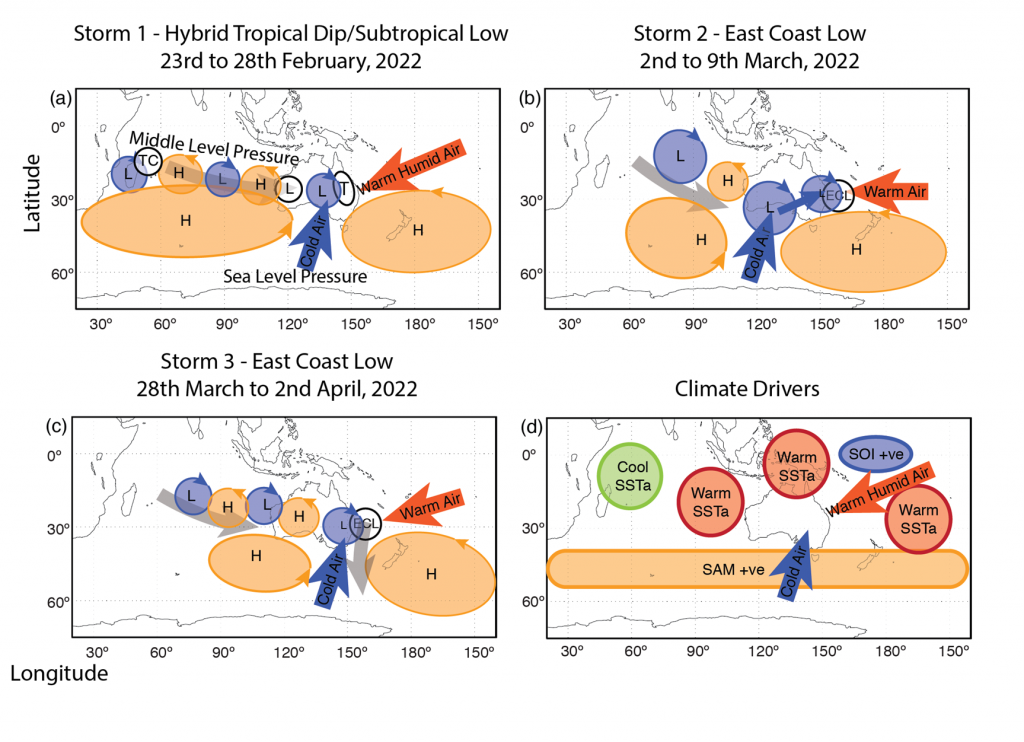
This was a hybrid storm because the tropical dip at the surface was a summer climate feature overlain and offset to the west by a mid to upper level cut-off subtropical low that is typical of mid-late autumn to spring climate. The combination resulted in drawing warm surface moist air flow in strong NE to E winds to mix with the mid level pool of cold air, and extreme precipitation and thunderstorm activity. The synoptic situation was maintained by the surface tradewind flow and the tropical low over New Caledonia, together with reinforcement of the cold air pool aloft. The latter was produced by a mid-level pressure wave (Rossby wave) that propagated eastwards in the subtropical jetstream from Tropical Cyclone Gombe located NE of Madagascar in the western Indian Ocean regions (10-20°S, 50°E). These Rossby waves are a fundamental feature of everyday weather but what was highly anomalous was that the wave propagated eastwards in the subtropics, impacting the Pilbara Heat Low and Western Australian Trough in WA and then merging with the cold air pool over SE Qld rather than tracking SE over the Indian Ocean to interact with weather systems over the Southern Ocean. The Rossby wave was guided by the subtropical jetstream to SE Qld due to the blocking high south of Australia. If this had not occurred, then the tropical dip/ subtropical low would have decayed much more quickly. (See Figures 1 to 3).
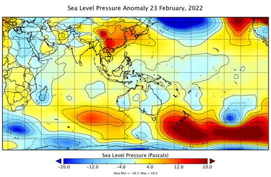
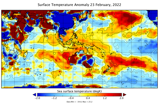

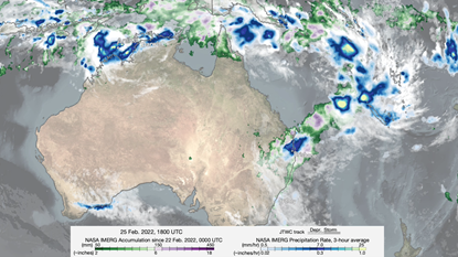
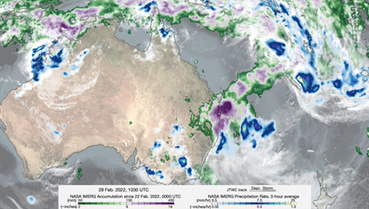
The hybrid tropical dip/subtropical low produced the highest February rainfall on record, the highest February total rainfall or the highest February total rainfall in the past 20 years, at many sites across SE QLD (from Wide Bay and Burnett Regions to Brisbane) and the Northern River region of NSW. Brisbane recorded its wettest February since 1893, with 887.0 mm, almost 500% of the average total. The highest February daily totals were achieved at 20 sites across SE Qld, ranging from 149 mm at Point Lookout to 345 mm at Alderley. In the Northern Rivers region of NSW, Rosebank (Upper Coopers Creek) recorded 701.8 mm on the 28th of February, the highest daily total in New South Wales since 1954 and in Australia since 1998, and the third-highest on record for the state. This led to the record flooding of the Lismore and downstream region on the 28th of February, that exceeded the previous record flood peak of March, 1974. (See the distribution of rainfall totals in Figures 4 and 5).
Storm 2: East Coast Low 28th February to 9th of March, 2022
The ECL development was typical of the evolution of inland trough systems to spawn ETLs when the trough extends SE over a warm northern Tasman Sea. These are characteristic of the eastern seaboard and are warm season storms (late summer to early winter) that either form: (i) in the extratropical transition of tropical cyclones and lows as they track south; or (ii) in a subtropical dip in the pressure field over the southern Coral Sea and Tasman Sea. The moist onshore air flows (E-SSE) result in heavy orographic rainfall over the eastern seaboard and typically contain embedded mesoscale lows within the overall low. The intensity of the ECL is determined mainly by the presence of a subtropical cut-off low or trough in the mid-upper atmosphere. This was the case from the 28th of February, 2022 when the cut off low formed further south than the week before over the northern Tasman Sea as the high to the south of New Zealand contracted. The result was a deep ECL that tracked parallel to the eastern seaboard, producing constant onshore airflow and orographic rainfall over the mid north coast, then central to Illawarra coast (between the 2nd and 8th of March) before tracking to the south of New Zealand’s South Island. Cooler than average night-time and daytime temperatures persisted during February and early March.
February rainfall totals in the Sydney region were greater than ~50-300 % above the monthly average prior to the onset of the ECL, with Sydney Observatory recording a total of 356 mm, Long Reef, 419 mm, and Wyong, 446 mm, which were record totals. The onset of the ECL produced flooding of the Macleay River at Kempsey and flash flooding in the central coast (Wyong), Sydney and Illawarra, with rainfall in excess of 100 mm in 2-3 hours at many locations. Persistent orographic rainfall over 3-4 days caused flooding in the Georges River and Hawkesbury-Nepean River system that was exacerbated by near-capacity dam storages.
Storm 3 East Coast Low 28th March to 2nd of April, 2022
An ECL formed off SE Qld and the Northern Rivers region of NSW on the 29th of March. This ECL evolved from a weak tropical low at the juncture of two trough lines in the Coral Sea. This is technically an easterly trough low and its formation over the Coral Sea in a dip in the tradewind flow is quite distinct from Storm 2, that developed in an inland trough over Queensland. Similarly, to Storm 2, the ECL Storm 3 intensified due to the formation of a mid-upper level cut-off low and cold air pool and the passage of a cold front. Its formation was also contemporaneous with a TL in the central Indian Ocean and then the formation of TC Charlotte in the NE Indian Ocean that tracked along the WA coast. Similar to Storms 1 and 2, the strong blocking highs over the Tasman Sea and mid-latitude Southern Ocean below Australia maintained a strong warm subtropical humid air mass to the NSW coast.
Storm 3 was not unusual for early autumn but it delivered another extreme weather event with anomalously high rainfall intensity and daily totals. The storm 3 ECL tracked parallel to the coast to East Gippsland, Victoria in an offshore trough that extended into the Southern Ocean. Rainfall spatial anomaly pattern migrated southwards from February to April, in accordance with seasonal transition. Unfortunately, the bullseye for maximum rainfall anomaly was situated over the Northern Rivers of NSW region resulting in a compound flood event. It subsequently delivered high rainfall totals to the Bellingen-Dorrigo region and then over the mid north coast, Sydney and the Illawarra regions. Some examples of daily totals that are indicative of the rainfall intensity are 431 mm at Alstonville, 282 mm at Ballina, 248 mm at Coffs Harbour and 264 mm at Dorrigo on the 30th of March.
The three storm events delivered anomalously high rainfall totals from Wide Bay to the Gold Coast in SE Qld, and across the Northern Rivers region of NSW. The rainfall totals for February and March were 1159 mm at Brisbane, 1390 mm at Ballina, 840 mm at Casino, 1235 mm at Dorrigo and 858 mm at Sydney (see Figure 6 for the distribution across SE Australia).
The slow-moving Storm 3 ECL intensified off the NSW Central coast from the 31st of March to 2nd of April with a gale force SSE wind over the western Tasman Sea. The long-fetch from 45 °S latitude generated a powerful large swell (up to 7 m significant wave heights) and a long period of 15 seconds. The narrow directional wave spectrum focussed the large long period waves on the northern corners of beaches from the Illawarra to the Central Coast, NSW. This caused severe beach erosion at the northern ends of beaches and also wave energy propagated into coastal lagoons such as at Wamberal, Avoca, Narrabeen and Queenscliff. This caused localised inundation.

The big question: What is the probability of each individual storm phase or the six-week cluster of storms?
Storm clusters are not unusual, as quasi-stationary atmospheric circulation with blocking highs and tropical troughs provides the background environment for the potential of storm development. However, the synoptic development of Storm 1 and the rainfall intensity of all storms were anomalous and record-breaking. During and after the storms, there has been strong discussion on defining the severity of the storm cluster. Media reports published unverified return intervals of between 1 in 50 years and 1 in 3,500 years. In addition, there has been a great deal of identifying analogue storm events based on rainfall intensities but mainly in terms of flood peaks. The weather impacts of the event have been compared to those of February 1893, March 1955, March 1974 and January 2011. However, care is needed because the first phase was an unusual hybrid event, particularly since most of the previous severe flood-producing storms in the SE Qld and Northern Rivers of NSW regions have involved tropical cyclone or low interactions. Table 1 and 2, below, list the candidate events that involved an inland trough low or tropical dip but most had a TC and TL interaction (after Callaghan and Power, 2014). A further subdivision of the past storm data will be required to identify the past occurrence of hybrid events, to develop a probability distribution. Our own work on reconstructing past subtropical low storm activity indicates that flooding of this magnitude and significant morphological changes to the flood plains and coastline occurred regularly between 1650 and 1750, and again during the 1860s and 1880-1890s (Browning and Goodwin, 2016, Goodwin et al., in submission 2022).
In comparison, the severity of the Storm 2 and 3 ECLs will be much easier to determine, although their recurrence interval should be assessed only from a population of moderate to severe events occurring in late summer (February and March) rather than for all ECLs occurring during mid-autumn and winter.
Comments on prediction based on climate drivers: the take home message.
The combination of La Niña and positive SAM, together with warm tropical SSTs in the Indo-Pacific region and cool SSTs in the western Indian Ocean, are the climate drivers associated with subtropical storm activity (Browning and Goodwin, 2013). This combination of drivers was present in the 2021/ 2022 summer (see Figure 7). What was unusual was the quasi-stationarity of the atmospheric circulation and that there were significant records in warm and cold surface air and sea surface temperature anomalies. In the Australian longitudes, these temperature anomalies spanned from Tropical North Queensland to the central East Antarctic plateau. This was definitely an outlier in the instrumental record of the past century.
The wild card of the weather was the intensification of a tropical cyclone off the NE of Madagascar that set up a remote atmospheric teleconnection between the western Indian Ocean and SE Qld in the mid atmosphere. This was repeated for storms 2 and 3, with TLs in the central Indian Ocean influencing the mid-atmosphere over Australia and propagating to the eastern seaboard. The role of these teleconnections in the intensity of the SE Queensland/ Northern Rivers NSW rainfall and flooding requires further research. Was this influence predictable or an unfortunate stochastic event?
We need to view this storm cluster in the context of back-to-back La Niña events, a La Niña-like state of the decadal Pacific Ocean, the positive SAM phase and anthropogenic warming of the atmosphere and ocean. Recent back-to-back La Niña events identified by the Oceanic Nino Index include 2021-2022, 2011-2012, 1999-2000, 1984-1986, 1974-1976, 1955-1956 and 1949-1951. Most of these periods have produced severe subtropical storm clusters in eastern Australia, and almost all occurred when the La Niña-like state of the decadal Pacific Ocean was dominant.
Was this event different to historical events due to climate change, either by rainfall intensity, wind speed or through atmospheric-ocean circulation anomalies? The killer ingredients were the blocking high and the very early season cold air outbreak from the circumpolar region that was associated with the breakdown of the strong positive SAM around the 10th of February. In the past few decades, there is a statistically significant trend towards more positive SAM summers that is attributed to the combined anthropogenic influence of ozone depletion and increasing greenhouse gas concentrations. Could cold air outbreaks be more frequent in summer, fuelling warm moist surface flow to drive explosive hybrid subtropical storms along the eastern seaboard? This would create an overlapping climate risk from both TC and ECLs. The migration of the peak ECL season into late summer-early autumn may increase the probability of severe climate risk.
References
Browning S.A., Goodwin I.D. (2013) Large-Scale Influences on the evolution of winter subtropical maritime cyclones affecting Australia’s east coast. Monthly Weather Review 141:2416–2431. doi: 10.1175/MWR-D-12-00312.1
Browning, S. A. and Goodwin, I. D. 2016, Large scale drivers of Australian east coast cyclones since 1851, Journal of Southern Hemisphere Earth Systems Science, (66), 146–171 [online] Available from: http://www.bom.gov.au/jshess/docs/2016/browning.pdf
Bureau of Meteorology, 2022. Recent climate statements for Greater Brisbane, NSW and Greater Sydney. http://www.bom.gov.au/climate/current/statements/
http://www.bom.gov.au/climate/rainfall/archive.shtml
Callaghan, J. and Power, S.B. 2014. Major coastal flooding in southeastern Australia 1860-2012, associated deaths and weather systems. Australian Meteorological and Oceanographic Journal 64, 183-213.
Goodwin, I.D, Browning, S.A, and Burke, A. (in submission 2022), Tasman Sea wave climate, coastal impacts and extreme storm activity in the context of large-scale atmospheric circulation, since 1500 CE. Quaternary Science Reviews.
Table 1
South East Queensland and Northern NSW Inland Tropical Trough Flooding Events in Summer and Early Autumn | |
Brisbane | 17 March, 1863 |
Grafton, Coraki | 24 Jan-4 Feb, 1890 |
SE Qld, Grafton | 24-28 March, 1890 |
Brisbane | 9-11 Jan, 1898 |
SE Qld and northern NSW | 27-29 Dec, 1921 |
Murwillumbah | 4-12 March, 1925 |
Brisbane, Murwillumbah and Lismore | 3-8 Feb, 1931 |
Murwillumbah, Coffs Harbour, Casino and Kyogle | 17-20 Jan, 1938 |
Coffs Harbour region | 1 Feb, 1938 |
Murwillumbah, Lismore and Grafton | 26-29 March, 1955 |
Clarence, Macleay and Nambucca regions | 9-13 Jan, 1968 |
Murwillumbah, Lismore, Grafton and Macksville | 11-13 March, 1974 |
Bowraville, Nambucca | 18-22 Dec, 1975 |
Kempsey and Lismore | 28 Feb-5 March, 1976 |
Coffs Harbour, Pine River and Ipswich | 11-15 Dec, 1991 |
Brisbane | 19-20 Jan, 1994 |
NSW Northern Rivers | 1-3 March, 1999 |
Brisbane and Bremer Rivers, Lockyer Creek and Clarence Rivers | 6-11 Jan, 2011 |
Tweed, Clarence and Bellinger Rivers, and Gold Coast | 22-27 Jan, 2012 |
Table 2
Mid Northern to South Coast NSW Inland Tropical Trough Flooding Events in Summer and Early Autumn | |
Hunter and Macleay | 8-12 Feb, 1864 |
Hunter, Maitland, Singleton and Morpeth | 26 Jan, 1874 |
Macleay and Kempsey | 26-27 Feb, 1875 |
Georges River Sydney | 18-20 March, 1892 |
Georges River, Illawarra, Moruya and Bega | 20-24 March, 1914 |
Sydney and Illawarra | 21-23 Jan, 1933 |
Hunter River, Maitland | 22-26 Feb, 1955 |
Nowra | 24-26 March, 1961 |
Hunter | Jan/Feb, 1971 |
Bega | 6-7 Feb, 1971 |
Georges River, Sydney | 20-22 March, 1983 |
Illawarra | 18 Feb, 1984 |
SE Qld to Coffs Harbour | 11-15 Dec, 1991 |
Mid North Coast to Illawarra | 2-6 Feb, 2008 |
Note: Only some of these events could be comparable since there was no interaction with a tropical low.
Table 3
Northern to South Coast NSW ECL Flooding Events in Summer and Early Autumn (Dec-March) | |
South Coast NSW | 8-10 Feb, 1860 |
Clarence, Richmond and Macleay Rivers | 18-21 March, 1870 |
Hunter to South Coast | 24-26 Dec, 1870 |
Sydney and Bega | 6-9 Feb, 1878 |
Georges, Manning and Hunter Rivers | 22-23 Jan, 1895 |
Nambucca and Hunter Rivers | 23-24 Feb, 1908 |
SE Qld | 12-13 Dec, 1910 |
Bega, Lake Illawarra | 25-27 Feb, 1919 |
Newcastle | 9-12 Dec, 1920 |
Macksville, Gloucester, Taree and Kempsey | 7-9 Feb, 1931 |
Sydney | 27-28 March, 1942 |
Bega and Hunter River, Maitland | 6-8 Feb, 1950 |
Hunter River, Maitland | 17-19 Jan, 1951 |
Georges, Hawkesbury and Shoalhaven Rivers | 9-11 Feb, 1956 |
Bega | 3-5 March, 1961 |
Hastings, Port Macquarie | 7-12 Jan, 1962 |
Hastings, Port Macquarie | 28-29 March, 1963 |
Nambucca, Macksville | 6-9 March, 1964 |
Mid North Coast, NSW | 24-25 Feb, 1975 |
Lismore, NSW | 2-3 March, 1975 |
Illawarra, Nowra | 22-24 Feb, 1977 |
Hunter and Illawarra | 3-4 March, 1977 |
Newcastle and Sydney regions | 28-29 Jan, 1978 |
Lismore | 4-5 March, 1987 |
Illawarra, Moruya | 9-10 Feb, 1992 |
Mid North Coast NSW | 7-9 March, 2000 |
Grafton, Coffs Harbour, Brisbane and Gold Coast | 8-9 March, 2001 |
Bellinger River and Nambucca River | 13-17 Feb, 30 March-2 April, 2009 |
South Coast NSW | 14-16 Feb, 2010 |
(After Callaghan and Power, 2014)
Click here to download a .pdf version of this briefing note.
About the author/s

Dr Ian D. Goodwin
- This author does not have any more posts.
