Cause of Recent Earthquakes in the Otway and Strzelecki Ranges, Victoria
- Briefing Note 496
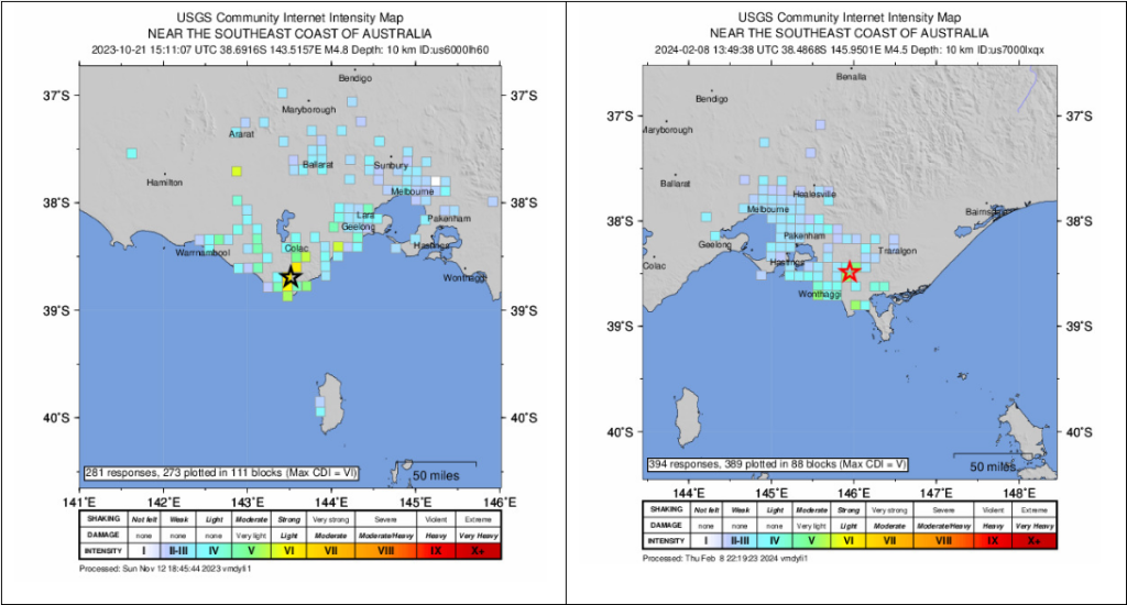
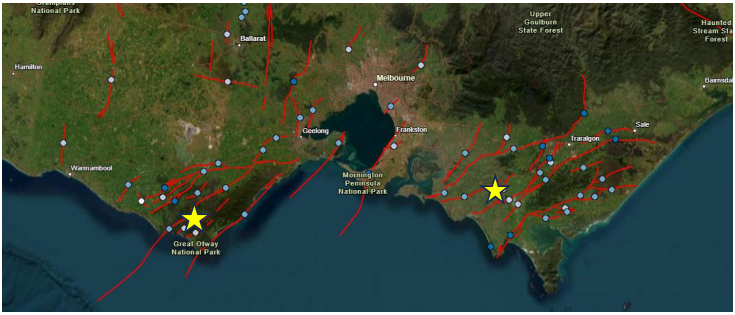
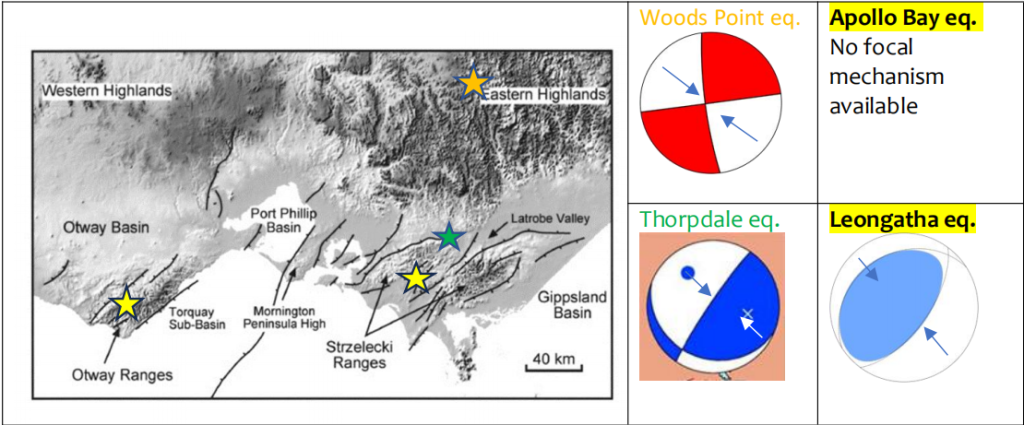
An earthquake of magnitude 4.8 occurred 16 km WNW of Apollo Bay in the Otway Ranges of Victoria on October 21, 2023 (Figure 1, left panel). This was followed on February 8, 2024 by a magnitude 4.5 earthquake 1 km SSE of Leongatha in the Strzelecki Ranges in the Latrobe Valley (Figure 1, right panel). Neither earthquake caused significant damage because of their small magnitudes, but they highlight the activity of recent faulting in the Otway and Strzelecki Ranges (Figures 2 and 3). The faults in Figures 2 and 3 are mostly striking in a northeast-southwest direction, perpendicular to the direction of maximum horizonal compression shown in the earthquake focal mechanisms on the right of Figure 3.

Cause of the Recent Earthquakes in the Otway and Strzelecki Ranges
As illustrated on the left side of Figure 4, the Pacific Plate is converging and colliding with the Australian Plate along the Alpine fault on the west coast of the South Island of New Zealand, as indicated by the orange arrows. The relative motion between these two plates generates strain elastic across their boundary, which is released periodically in earthquakes according to Reid’s Elastic Rebound Theory (USGS, 2024), as shown schematically in the right panel of Figure 5. The part of the convergence that is parallel to the fault is accommodated by large strike-slip earthquakes (centre panel of Figure 5) on the Alpine Fault; there have been four major earthquakes (about Mw 8) on this fault in the past 900 years. The part of the convergence perpendicular to the fault is partly accommodated by earthquakes that cause crustal shortening on either side of the fault. In the past ten years, that shortening has occurred in both the Canterbury Plain in the 2010 Mw 7.0 Darfield and 2011 Mw 6.2 Christchurch earthquakes, and in southern Victoria in the 2016 Mw 4.9 Thorpdale, 2021 Mw 5.9 Woods Point, and 2023 Mw 4.8 Apollo Bay and Mw 4.5 Leongatha earthquakes. This crustal shortening is very gradually reducing the width of the Tasman Sea.
The fault planes of the 2016 Thorpdale and 2023 Leongatha earthquakes (Figure 3) and 2011 Christchurch earthquake (top right panel of Figure 4), all reverse faulting earthquakes (left panel of Figure 5), are all oriented northeast-southwest, causing shortening in the northwest-southeast direction. The fault planes of the 2021 Woods Point (Figure 3) and 2010 Darfield (Figure 4) earthquakes are both strike-slip earthquakes (centre panel of Figure 5) having roughly north-south and east-west strikes respectively, with shortening in the northwest-southeast diagonal direction in both cases.
How Earthquakes Cause Crustal Shortening
Reverse faulting on dipping fault planes directly reduces the distance between the two sides of the fault in the direction of fault motion, as illustrated on the left panel of Figure 5. Strike-slip faulting on vertical fault planes reduces the distance diagonally at 45 degrees in the northwest-southeast direction and increases the distance diagonally at 45 degrees in the northeast-southwest direction, as illustrated in the centre panel of Figure 5.

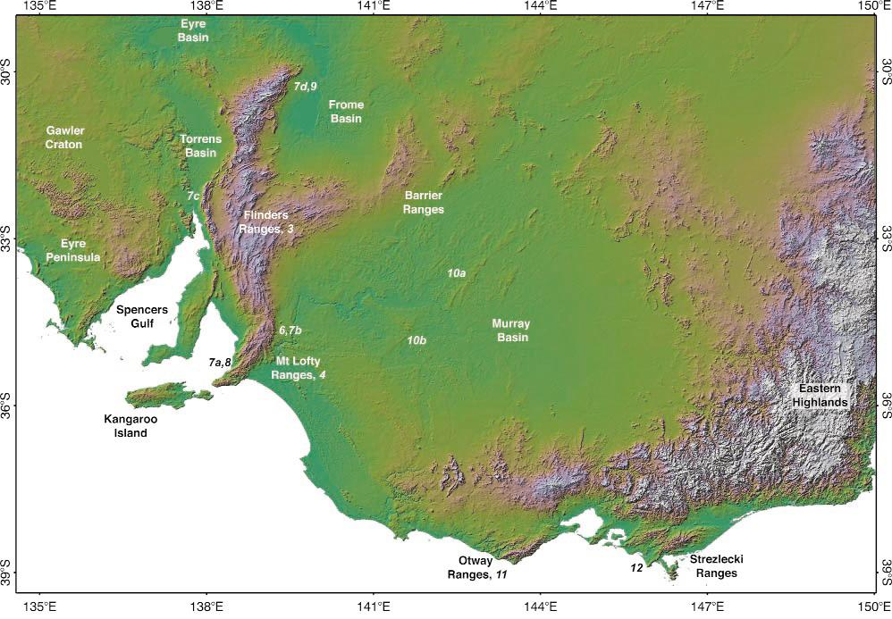
The topographic map of southeastern Australia in Figure 6 shows the Flinders and Mt. Lofty Ranges of South Australia which, like the Otway and Strzelecki Ranges of Victoria (but unlike the Eastern Highlands), are in phases of active mountain building due to earthquakes occurring on the faults shown in Figures 2 and 3. This causes crustal shortening in a NW-SE direction across these mountain ranges.
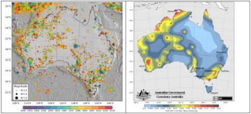
The contributions of the active faults of the Flinders and Mt. Lofty Ranges and the Otway and Strzelecki Ranges are evident in the historical seismicity of Australia (left side of Figure 7) and the probabilistic ground motion map (right side of Figure 7), especially in the recent activity in the Strzelecki Ranges.
References
Allen, T. (2023). Updating the National Seismic Hazard Assessment: Philosophy and Implications. Proceedings of the 2023 Annual Conference of the Australian National Committee on Large Dams, Cairns, October 2023.
Geoscience Australia (2023). Neotectonic Feature Database. https://neotectonics.ga.gov.au
Risk Frontiers (2021). Mansfield (Woods Point) earthquake 22 September 2021 magnitude 5.9 – what caused it, and preliminary impacts. Risk Frontiers Briefing Note 454.
Sandiford, M. (2003). Chapter 8—Neotectonics of southeastern Australia: linking the Quaternary faulting record with seismicity and in situ stress. Geological Society of Australia Special Publication 22, 101–113.
United States Geological Survey (2024). Reid’s Elastic Rebound Theory. https://earthquake.usgs.gov/earthquakes/events/1906calif/18april/reid.php
About the author/s

Paul Somerville
Paul is Chief Geoscientist at Risk Frontiers. He has a PhD in Geophysics, and has 45 years experience as an engineering seismologist, including 15 years with Risk Frontiers. He has had first hand experience of damaging earthquakes in California, Japan, Taiwan and New Zealand. He works on the development of QuakeAUS and QuakeNZ.
