
‘Astounding’: Shifting storms under climate change to worsen coastal perils
This was the headline of a news report in the Sydney Morning Herald last week (July 20). The article (and others in the media recently) is based on a research article published by fellow OEH Coastal Process Node members UNSW Water Research Laboratory (Harley et al., 2017). The paper reports on observations of the June 2016 East Coast Low (ECL) storm along the NSW coast, and highlights the importance of storm wave direction in determining coastal erosion magnitude.
To quantify coastal impacts, the authors undertook repeat airborne measurements of beaches along the coast before and directly after the June 2016 ECL. At Narrabeen-Collaroy the erosion magnitude was the largest in four decades. They attribute this to the storm’s anomalous wave direction and call for greater attention – from both research and management – on the impacts of changing storm wave direction in a changing climate.
Agreement of observations and modelling
It is encouraging that observations from this work echo the same conclusions made by Risk Frontiers’ modelling study of this storm, published back in February in the open-access journal Water (http://www.mdpi.com/2073-4441/9/2/121).
In this paper, we compared the impacts of a ‘regular’ ECL – with waves coming from the south-east, with the anomalous 2016 event where waves came from the east to north-east.
We demonstrated the reason for the large erosion was the anomalous wave direction focussing energy at sections of the coastline not equilibrated with high wave exposure. This was particularly damaging at Collaroy because the easterly extension of Long Reef headland set up a mega rip-current circulation, lowering the beach and focussing erosion at this location (Figure 1).
This agrees with the recently-published observations of Harley et al. (2017) that sites in the south and central sections of beaches along the NSW coast suffered the worse beach losses, and that erosion at Collaroy-Narrabeen was the largest seen in four decades.
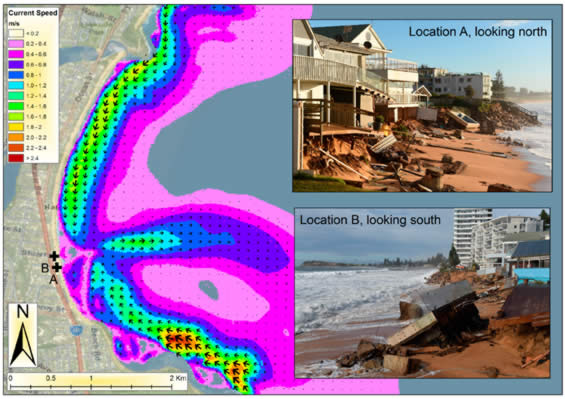
Changes to wave direction as the tropics expand
A number of media reports have linked this event to a sign of things to come, with the expectation that “storm direction will shift in the future with climate change”, but the mechanism for this is perhaps not clear.
Over the past 30 years, there has been a measured expansion of the tropics at a rate of about 0.5 – 1.0 degree latitude per decade, in both hemispheres (Lucas et al., 2014). Most Global Climate Models (GCMs) predict the expansion trend to continue with global warming.
As the tropics expand, more tropical-origin storms – like the 2016 ECL, tropical lows or tropical cyclones – are likely to become a more common feature of the storm wave climate along the NSW coast (outside the tropics), replacing the traditional storm types that have their origin in the Tasman Sea or Southern Ocean (Goodwin et al., 2016).
This means the average storm wave direction may shift towards the east or north-east (coming from), as opposed to the current south-east direction of most ECL storms. As witnessed in June 2016, the storm wave direction is of key importance in determining erosion magnitude.
The topic of directional wave climate change and coastal response has been a core research theme for the past 30 years at the Marine Climate Risk Group at Macquarie University, a group with which Risk Frontiers works closely.
The Catalyst program Stormageddon, aired on ABC in July 2016, provides a good overview on this topic, featuring A/Prof Goodwin of the Marine Climate Risk Group (http://www.abc.net.au/catalyst/stories/4503317.htm).
References
Goodwin, I.D. et al. (2016), Tropical and extratropical-origin storm wave types and their influence on the East Australian longshore sand transport system under a changing climate, J. Geophys. Res. Oceans, 121, 7.
Harley, M.D. et al. (2017), Extreme coastal erosion enhanced by anomalous extratropical storm wave direction, Sci. Rep., 7, 6033.
Lucas et al. (2014), The expanding tropics: a critical assessment of the observational and modeling studies, Wiley Interdiscip Rev, 5, 1.
Mortlock, T.R. et. al. (2017), The June 2016 Australian East Coast Low: Importance of Wave Direction for Coastal Erosion Assessment, Water, 9(2), 121.