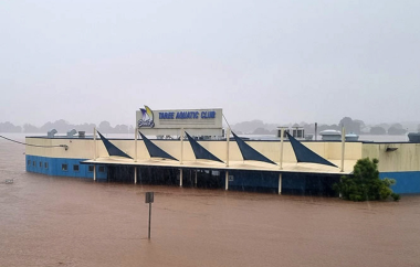
An Easterly Trough Low (ETL) is continuing to severely impact the NSW Mid North Coast. It has brought heavy locally intense rainfall, resulting in major flooding along the Manning River, Hastings River, Macleay River and Nambucca River. The flooding at Taree was in excess of the 500-year average recurrence interval (ARI) level. As of Friday morning (23 May), there are four confirmed fatalities, one person missing, more than 670 flood rescues have been carried out, and 9,500 households have been told to evacuate.
The Easterly Trough Low
On Thursday 22 May, a trough was extending over the Byron Coast and into the northeastern districts of NSW. This area of low pressure brought widespread showers with an extensive area of cloud to the Mid North Coast.
The record rainfall was a result of several atmospheric phenomena all converging on one location. A near-stationary high to the south was propelling strong winds of very moist air from the Tasman Sea into a trough near the coastline.
The trough located near the coast was then lifting this relatively warm, humid air. This results in the formation of thick cloud and rain. Pools of cold air drifting over inland NSW were then enhancing this process.
This process continued along the Mid North Coast until Friday. The 48 hours afterwards will then see the system become more widespread, moving south and engulfing central and southern NSW, along with eastern Victoria. The system could then result in flooding in other areas including Sydney, with extreme rainfall totals predicted for Friday.
So far the system has resulted in gale force wind warnings for the Coffs Coast, Macquarie Coast and Hunter Coast areas. There are also heavy surf warnings for beaches between Seal Rocks and Smoky Cape and this could reportedly lead to localised damage and coastal erosion. There are also several minor to major flood warnings for the Mid North Coast, Hunter, Central Coast, Northern Rivers and Sydney catchments.
Significant rainfall observations in the 24 hours to 9am Thursday morning have included 336 mm at Bellingen, 323 mm at Moparrabah, 242 mm at Englands Road (Coffs Harbour), 240 mm at Kooroowi, 200 mm at Woolgoolga Dam, 169 mm at Kempsey Airport, and 160 mm at Belleview Park (Dorrigo).
So far four rivers have reached the major flood level; the Nambucca River at Macksville, the Macleay River at Kempsey, the Hastings River at Wauchope Railway Bridge and Settlement Point, and the Manning River at Wingham, Taree and Croki.


Flooding
Several coastal towns on the Mid North Coast have experienced significant flooding. For Taree, flooding has been extreme with the Manning River reaching its highest level on record at the Martin Bridge gauge around 6pm on Wednesday 21 May at 6.44 m AHD. This depth exceeded the previous record set in 1929 (5.9 m AHD) and the 500-year ARI level of 6.2 m AHD and could have a greater than 600-year ARI depending on the interpolation approach used.
At Kempsey, the Macleay River breached the levee in the CBD, resulting in parts of the town being flooded. Meanwhile, parts of Port Macquarie are flooded, as well as several other towns along the Hastings River.
There are fears several towns may be isolated due to the flood waters. This may last several days, putting strain on food and clean water supply. Sections of the Pacific Highway have been closed in both directions due to flooding, and several other low-lying roads from the Central Coast to Yamba are underwater.

Impact
So far four people have lost their lives – a man was found dead in a flooded house at Moto north of Taree; a man in his 30s was found in floodwaters at Rosewood near Wauchope after driving through floodwaters; a 60-year-old woman who was driving through floodwaters around Brooklana north of Coffs Harbour, and a man in his 70s was found dead in his car in floodwaters north-west of Coffs Harbour. There is also one person missing, a 49-year-old male who was last seen crossing a flooded causeway.
There have been over 670 flood rescues that have been carried out. Notably, more than 339 of these occurred in the 24 hours to 9am Thursday 22 May. In the region there are 18 helicopters assisting emergency services, 8 dedicated to rescues and the remainder for food delivery and logistics. On Thursday 9,500 households had been told to evacuate, and 50,000 people were under warnings to prepare to evacuate or isolate as they were expected to be isolated by rising floodwater. All up there are over 140 warnings in place. NSW Premier Minns has warned that people delaying their evacuation are putting themselves at risk, noting there are not enough helicopters to rescue everyone, stating “we don’t have 9,500 helicopters”.
Grocery stores in Kempsey and Macksville have closed due to the flood warnings, limiting food supply for residents. Major roads are also underwater, restricting access for the delivery of food and clean water. There is also a warning of faecal matter and sewage in the floodwater, with residents advised to fill containers with clean drinking water whilst it is available. Nearly 150 schools are also closed, as well as 101 childcare centres. Livestock are also tragically being washed down waterways, with dead cows washing up on NSW beaches.
Due to the devastation of this event, Disaster Recovery Allowance payments have been activated. This allowance is so far available for eligible people in the four local government areas of Dungog, Kempsey, Mid Coast and Port Macquarie-Hastings.
** Some figures have been sourced or generated from data from the Australian Government Bureau of Meteorology (BoM) under Creative Commons (CC by 4.0). BoM does not endorse this Briefing Note or the information contained within.
This Briefing Note is dated 23 May 2025. Please note that this event is ongoing and therefore may not be complete or accurate and was based on information leading up to this time.