Manning River Catchment, June 2025
Between 19 and 25 May 2025, severe flooding occurred across the NSW Mid North Coast when an Easterly Trough Low (ETL) combined with warm, humid conditions to produce intense rainfall, gale-force winds, and major flooding. The event affected the Manning, Hastings and Macleay catchments, leading to five confirmed fatalities, an estimated 10,000 homes damaged, 50,000 people evacuated, and widespread power outages and transport disruption (Figure 1).

This briefing note is Part One of a two-part series, summarising Risk Frontiers’ flood impact and resilience field survey conducted in June 2025 (Read part II). It focuses specifically on the Manning River catchment, including the communities of Taree, Glenthorne, Wingham, and Croki. This research outlines the extensive damage sustained by housing, businesses, and primary production, while reflecting on community recovery experiences and drawing out key insights to strengthen resilience and reduce future flood risk.
Manning River Catchment: Flood Event and Community Impacts
Event Overview
-
- Record-breaking flood levels: The Manning River at Taree peaked at 6.5 metres, exceeding the 1929 record by half a metre
-
- Rapid river rise: At Wingham, the river rose over 13 metres in two days (Figure 3)
-
- Taree and Wingham received more than 700 mm of rainfall, more than doubling previous May records
-
- The widespread inundation isolated thousands of residents and severely impacted housing, infrastructure, businesses, and rural properties.
Key Findings – Manning River Catchment
Emergency Warnings and Community Trust
-
- Residents in Taree and Glenthorne described official warnings as delayed and vague, undermining trust. Many relied instead on local observations and informal networks
-
- Examples included reports of evacuation notices issued only after roads were already impassable.
Community and Business Preparedness
-
- Taree Aquatic Club staff applied informal lessons from 2021 but were unprepared for the record 2025 levels. Flood levels rose more than 1 metre inside the first floor (Figures 5(a),(b),(d)), causing an estimated $1.5 million in losses
-
- The Taree University Campus suffered significant damage with water levels reaching 1.2 metres on the first floor and completely inundating basements and the underground carpark (Figure 7). Cleanup was complicated by rapid river rise and sediment deposition
-
- Pulteney Arcade in Taree CBD was inundated to 2.2 metres. Only one of nine businesses reopened quickly, highlighting flexible, experience-based planning versus rigid protocols
-
- Celebration Bottle Shop in Wingham demonstrated exemplary preparedness with structural modifications and stock relocation, resulting in zero losses (Figure 10)
-
- In contrast, Coles Wingham lacked a practical flood plan. Corporate rules forced total stock disposal due to contamination risk, resulting in prolonged closure and local supply disruption.
Housing and Social Impacts
-
- In Taree alone, 608 homes were deemed uninhabitable (at the time of research), the highest number across Mid North Coast LGAs
-
- The Taree Recovery Centre recorded over 1,073 visits in six days, with common needs including financial aid, emergency accommodation, and food security.
Rural Recovery – Manning Valley Farmland and Croki
-
- Croki and Manning Valley farmland experienced record-breaking inundation (Figure 11), with water heights reported at three times previous events
-
- Losses included significant livestock, feed, and equipment damage. Recovery has been slowed by saturated paddocks and impassable roads which has limited the access of heavy machinery.
Community Resilience and Support
-
- Residents in Taree, Glenthorne, Wingham, and Croki noted strong local volunteer support, informal community networks, and grassroots aid as critical to recovery
-
- Glenthorne residents faced especially high losses, with many uninsured due to prohibitive costs (e.g., quotes up to $60,000/year). The community relied heavily on neighbours and family.
Warnings and Local Knowledge
-
- Consistent across all areas was frustration with official forecasts. Residents and business owners in Taree and Wingham increasingly used social media, word-of-mouth, and local rain gauge data for timely information
-
- This informal sharing helped some businesses like Snow & Sons Butchery in Wingham resume trade within four days, despite no formal assistance.
Manning River catchment – Taree, Glenthorne, Wingham, Croki

Manning River catchment
Between 19 and 23 May 2025, the Manning River catchment, including Taree and surrounding areas, experienced a severe and record-breaking flood event (Figure 2). The Manning River at Taree peaked at 6.5 metres, exceeding the previous record set in 1929 by half a metre, and isolating thousands of residents.
-
- Many Taree residents noted the Manning River rose and fell much faster than in 2021, confirmed by the Wingham hydrograph showing over 13 metres between 12 p.m. on Monday, 19 May and 12 p.m. on Wednesday, 21 May, highlighting the speed and intensity of the event upstream (Figure 3).

Areas Impacted
Taree
-
- Record river levels (6.5m) caused widespread inundation of homes, businesses and infrastructure
-
- Thousands were isolated by floodwaters.
Wingham
-
- Extreme rainfall doubled past May records
-
- Flooding submerged rural roads, farmland and homes.
Glenthorne (Southern Bank of the Manning River)
-
- Nearly all properties flooded; only one elevated home escaped
-
- Major damage due to the low-lying location opposite Taree CBD.
Manning Valley Farmland and Rural Roads (Croki)
-
- Flooding severely impacted low-lying farms and roads
-
- Major stock and equipment losses, with restricted access delaying recovery.
Taree Recovery Centre
The Taree Recovery Centre provided vital support, recording 1,073 visits in six days, with many residents needing financial help, housing and food support.
Primary Needs Identified
-
- Financial insecurity, housing displacement, food insecurity and broader social vulnerability were widespread.
Housing Impact
-
- Damage assessments found 608 homes in Taree uninhabitable the highest number for any affected LGA – highlighting the disaster’s scale.
Rural Recovery Challenges
-
- Rural recovery in Taree and Croki was slowed by unclear impact assessments, waterlogged paddocks and road closures, making heavy machinery access difficult.
Taree CBD – Northern bank walkway and park
The northern bank of the Manning River (Figure 4) in the Taree CBD experienced severe flooding in 2025, with water levels at least 1.2 metres higher than in 2021, causing major environmental and infrastructure impacts.
-
- A major concern was the extensive deposition of contaminated soil and silt along the riverbank. Over 400 mm of sediment buried grassed parklands and walkways, disrupting open spaces
-
- Cleanup crews worked to pile and remove the soil to restore the grassed areas
-
- The sediment was classed as ‘black water contaminated’, containing animal waste and likely sewage, producing a strong odour. It was marked for landfill disposal under health safety protocols.

The Taree Aquatic Club (Taree CBD)
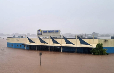
The Taree Aquatic Club (‘Sailos’) was submerged by floodwaters that rose over one metre higher than the 1978 and 2021 floods, showing the exceptional intensity of the 2025 event which reached over 1 metre inside the first floor (Figures 5 (a), (b) and (d)). Its location on the Manning River adds significant flood risk and makes it ineligible for flood insurance, compounding financial vulnerability.
-
- Extreme rainfall, with 630mm in four days and 260mm on 21 May alone, caused the rapid river rise and flash flooding. Oversaturated soil worsened impacts an led to longer disruptions like power outages
-
- The damage is extensive, with estimated losses of at least $1.5 million, including:
-
- Loss of 37 poker machines (Figure 5(c))
-
- Destruction of a large industrial kitchen left in place
-
- Loss of tables, chairs, soft furnishings, and partial flooring damage, though carpets are being salvaged.
-
- Electricity outages and saturated infrastructure (e.g., submerged systems and kitchen facilities) slowed clean-up and complicated reopening plans.
Informal flood planning
-
- The club’s staff used an informal flood plan based on lessons from 2021, including moving valuable items from the basement to higher ground and acting quickly to protect stock and equipment. This shows how institutional memory can support flood planning even without formal protocols
-
- Cleanup began immediately after the flood, with debris removed, damaged items inventoried, and replacements ordered-avoiding the long delays experienced in 2021. Staff also worked to dry carpets using industrial fans
-
- The club expects to reopen in just 3–4 weeks, much faster than the 12-week closure in 2021, showing improved coordination, resilience, and better post-disaster response.

Warnings
-
- Warnings about the flood’s intensity and scale were untimely and vague, giving staff little chance to fully protect assets, so most measures were ineffective
-
- Club members reported a general loss of trust in official warning systems due to inaccurate and slow forecasts in two major events over four years. Some noted that just before the rapid flooding, official forecasts for Taree CBD only predicted minor flooding
-
- Several people in Taree now use broader local networks for flood information, saying nearby rain gauges and farmers’ observations were more accurate than official alerts, highlighting a need to better integrate local knowledge
-
- The club received no help from local or state authorities, relying instead on its own resources and private support, though they are getting logistical advice from Clubs NSW.
-
- After the 2021 flood, management considered raising the building by 1 metre, but the 2025 flood showed this wouldn’t have kept water out of the first floor (see Figure 6). Club management are now exploring a 2-metre lift as a possible long-term protection
-
- Staff see this event as a chance to rethink resilience strategies and strengthen continuity plans, with elevation showing a clear commitment to long-term risk reduction.

Taree University Campus (Taree CBD)
The Taree University campus in the CBD suffered significant damage in the 2025 flood. The ground floor, newly tenanted by the Local Health District only seven weeks earlier, along with admin and teaching areas, was heavily affected. Cleanup crews were two weeks into debris removal ahead of a planned one-month refit for first-floor offices and lecture rooms.
-
- Despite severe flooding, some of the interior (upper)-gyprock panels, electronics, and furnishings-was assessed as salvageable. However, on-site management still estimated at least $1 million in losses, with 30 truckloads of waste sent to landfill. First-floor clean-up was still underway at the time of the survey (Figure 7(a)).
-
- The Manning River’s rapid rise made it impossible to protect assets. The adjacent park saw at least 400 mm of sediment deposited. The building was inundated to about 1.2 metres on the admin level, with basement levels exceeding 2 metres, now requiring moisture testing to ensure structural and health safety (Figure 7(b)).

-
- This highlights the need for rapid impact forecasting and asset protection, especially for shared buildings, and shows how vulnerable newly occupied sites are without proper flood resilience plans.
Glenthorne (Southern bank of Manning River to Taree CBD)
Glenthorne on the southern bank opposite Taree CBD was severely impacted. All but one elevated home experienced flooding. Residents reported floodwaters rising over 1 metre, with strong currents carrying large debris (Figure 8(c)).
-
- Significant structural damage occurred, including wall collapses from debris like logs and hay bales (Figure 8(a)). Vehicles were swept into paddocks, fences collapsed, and hundreds of hay bales scattered or torn apart by fences (Figure 8(b))
-
- Residents described delayed evacuation notices, with some receiving alerts only when roads were already impassable. Some needed to escape through windows into boats and by helicopter, showing major gaps in early warnings. Residents felt terrified by the speed and height of the water, which overtopped paddock gates and fences (Figure 8(d))
-
- Some were hesitant to evacuate due to unclear information about destinations, pets, and logistics-highlighting gaps in readiness and communication
-
- Many households reported total losses, including homes unaffected in 2021. No residents interviewed had flood insurance; one reported a quote of $60,000/year, making coverage unaffordable.

-
- The 2025 flood showed a dramatic increase in reach and severity, turning areas that hadn’t flooded before into high-risk zones
-
- Recovery has mostly depended on help from family, neighbours, and volunteers, with little formal support; some residents only received small vouchers from relief agencies
-
- There is growing community concern about local government planning, especially new developments on nearby floodplains that could worsen future flood risks.
Pulteney Arcade Flood Impact – Taree CBD
During the 2025 flood, Pulteney Arcade was inundated to 2.2 metres. Of nine businesses in the centre, only one was operating after the flood.
-
- A staff member at Ignite Sports Nutrition said they had only half a day’s notice to move stock, closing by 5:20 p.m., mostly using river gauge readings since formal warnings were inconsistent and spread by word of mouth
-
- Despite raising stock to the 2021 flood height, the higher 2025 level caused about 70% inventory loss and structural damage, including smashed windows. They reopened within five days, selling stock at half price with warnings to customers, crediting their quick response to lessons from 2021
-
- Arcade management estimated over 100 businesses nearby were evacuated, and confirmed that eight of nine arcade tenants would not be renewing leases as a result. Most businesses had 2-3 staff, showing a clear impact on local jobs
-
- The manager stressed the need for better real-time flood gauge data for decision-making.
Wingham
The Bight
The Bight Bridge at Wingham was badly damaged, with over half washed away, cutting travel between Tinonee and Wingham. Severe riverbank erosion showed how powerful the floodwaters were (Figure 9).
-
- Mid Coast Council confirmed the bridge will be replaced at minimum like-for-like through Natural Disaster Recovery funding, with work focused on restoring this critical link.

Wingham Brush Nature Reserve
The Wingham Brush Nature Reserve, next to the public school, faced extreme flash flooding.
-
- A large volume of water swept through, destroying minor infrastructure and leaving debris like trees, vegetation, water tanks, and roofing materials
-
- Notably, a recently upgraded riverside recreation area and campsite were completely destroyed, highlighting the risk to riverside assets and the need for better land-use planning and hazard zoning.
Celebration Bottle Shop (Wingham CBD)
The Celebration Bottle Shop is a strong example of local resilience. Even though the 2025 flood levels were higher than in 2021 (confirmed by flood markers and Risk Frontiers’ 2021 survey, Figure 10(b)), the business suffered no losses.
-
- Badly affected in 2021 with about $1 million in uninsured losses, the owners applied those lessons in 2025 by:
-
- Pre-emptively evacuating stock on 20 May using a Pantech truck.
-
- Making structural changes after 2021, such as removing soft furnishings, plasterboard, and carpet tiles, and using flood-resilient materials like concrete floors and removable wine box shelving (Figure 10(a)).
-
- Badly affected in 2021 with about $1 million in uninsured losses, the owners applied those lessons in 2025 by:
-
- All refrigeration units survived and the store reopened within a week. The manager credited their preparedness mindset and noted that official warnings underestimated the flood’s speed, which validated their decision to act independently
-
- This example shows how informal, community-led planning, especially in Taree, Wingham, and Port Macquarie (Briefing Note 516(b)), has improved since 2021-unlike in places like Kempsey, where this adaptive approach was less evident.

Coles Supermarket (Wingham CBD)
In stark contrast to the Celebration Bottle Shop, Coles Supermarket in Wingham was heavily affected and remains closed for a full refit. Unlike 2021 when the store avoided damage, the 2025 flood saw about 50 cm of water on the shop floor.
-
- Corporate policy required all stock, even sealed items and cleaning supplies, to be condemned due to black water contamination and rotting perishables. Fridges and freezers, regardless of working condition, were also unsalvageable
-
- Over 40 skip bins of contaminated stock were removed to landfill, highlighting the hygiene and liability challenges faced by big retailers. Staff described the store as “rancid” after re-entry because of the smell of rotting food left in floodwater
-
- There was no workable flood plan, and staff said moving such a large volume of stock quickly wasn’t realistic
-
- The logistical unreality to quickly transport vast volumes of stock and to find off-site storage which adhere to strict risk policies show how rigid corporate protocols limit resilience
-
- This contrast with the Celebration Bottle Shop highlights the gap between rigid, policy-driven approaches and flexible, community-based responses. Smaller businesses adapted better, while large chains struggled to bounce back
-
- Local residents are concerned about the indefinite closure of Wingham’s only major grocery store. Many now rely on bulk grocery deliveries from Taree, a disruption likely to continue for some time.
Plaza Butcher – Snow & Sons (same complex as Coles)
The butcher shop closed for four days but was the first in the area to reopen, showing strong resilience and preparedness.
-
- Water levels stayed under one metre, so the shop avoided structural damage and stock loss; a missed meat delivery on the day of the flood also helped avoid spoilage
-
- Operating in a wet environment helped make clean-up quick and manageable, allowing trade to resume fast
-
- The business received no formal support during or after the flood
-
- Flood warnings were gathered through social media, with the owner saying they don’t rely on SES or BoM alerts -showing a lack of trust in official warnings in the local business community.
Croki
Croki, a small rural area north of Taree, was hit hard by the May 2025 floods, with record-breaking inundation that submerged homes, farmland, and local infrastructure (Figure 11).
Key Impacts
-
- Unprecedented Flood Levels – Residents said water reached three times higher than ever before, causing widespread damage to homes and properties
-
- Agricultural Losses – Dairy farms suffered heavily with stranded livestock, submerged pastures, and significant damage to land and equipment, resulting in big financial losses
-
- Infrastructure Disruption – Power outages from fallen trees, debris, and flood-damaged systems added to the impact. Roads were still impassable during the survey due to debris and mud and clean-up crews blocking roadways.
Community Response
Despite the severe impacts, local community and emergency services responded quickly. Grassroots support, such as FARM ANGELS on Instagram, provided vital help and relief, showing strong local resilience and cooperation.

References
1. ABC News – Cows huddle on high ground on a flooded farm at Croki. (Supplied: Craig Emerton). Source: https://www.abc.net.au/news/2025-05-21/mid-north-coast-hunter-farmers-devasted-by-flooding/105319008
2. Bastille Post Global –
Large number of houses in Australia’s Croki declared uninhabitable, unsafe after floods. https://www.bastillepost.com/global/article/4884308-large-number-of-houses-in-australias-croki-declared-uninhabitable-unsafe-after-floods